IMAGES TAKEN NEAR TO
Yarlington, WINCANTON, BA9 8DE
Introduction
This page details the photographs taken nearby to BA9 8DE by members of the Geograph project.
The Geograph project started in 2005 with the aim of publishing, organising and preserving representative images for every square kilometre of Great Britain, Ireland and the Isle of Man.

There are currently over 7.5m images from over14,400 individuals and you can help contribute to the project by visiting https://www.geograph.org.uk
Image Map
Images are licensed for reuse under creativecommons.org/licenses/by-sa/2.0
Notes
- Clicking on the map will re-center to the selected point.
- The higher the marker number, the further away the image location is from the centre of the postcode.
Image Listing (19 Images Found)
Images are licensed for reuse under creativecommons.org/licenses/by-sa/2.0
Image
Details
Distance
1
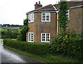
Old Toll House, Yarlington
The Old Toll House, Green Lanes, Yarlington, BA9 8DE.
Grade II listed.
List Entry Number: 1307562 https://historicengland.org.uk/listing/the-list/list-entry/1307562
Surveyed
Milestone Society National ID: SO.BRA
Image: © Alan Rosevear
Taken: 3 Sep 2009
0.01 miles
2

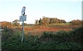
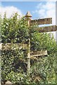
Old Direction Sign - Signpost by The Old Toll House, Bratton Seymour parish
Pyramid finial - 4 arms; Somerset SCC pyramid by the UC road, in parish of Bratton Seymour (South Somerset District), Green Lanes, Yarlington, by tollhouse: SO.BRA Image
Surveyed
Milestone Society National ID: SO_ST6629
Image: © Alan Rosevear
Taken: 3 Sep 2009
0.02 miles
4
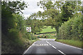
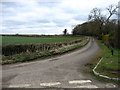
A371 junction
A view looking northeast across the A371 to the split-Y junction with the minor road from Shepton Montague.
Image: © Phil Williams
Taken: 5 Mar 2006
0.04 miles
5
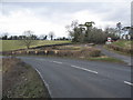
Road into valley of River Cary from Castle Hill junction
Image: © David Smith
Taken: 9 Jul 2019
0.05 miles
6
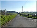
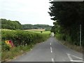
A minor road near Yarlington
This short 'cut-through' to the A371 is not signed here as a one-way street, but at the other end it is firmly marked 'No Entry'. So locals must have a bit of a shock if they encounter a car coming towards them, perhaps from the driveway that can be seen beyond the hedge on the right.
Image: © David Purchase
Taken: 11 Mar 2013
0.05 miles
9
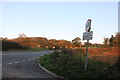
Old Direction Sign - Signpost on the A371
Pyramid finial - 4 arms; Somerset SCC pyramid by the A371, in parish of Bratton Seymour (South Somerset District), on the southwest corner of the three-cornered junction of the A371 and Cattle Hill.
Surveyed
Milestone Society National ID: SO_ST6629A
Image: © J Dowding
Taken: Unknown
0.09 miles