IMAGES TAKEN NEAR TO
Holton, WINCANTON, BA9 8AZ
Introduction
This page details the photographs taken nearby to BA9 8AZ by members of the Geograph project.
The Geograph project started in 2005 with the aim of publishing, organising and preserving representative images for every square kilometre of Great Britain, Ireland and the Isle of Man.

There are currently over 7.5m images from over14,400 individuals and you can help contribute to the project by visiting https://www.geograph.org.uk
Image Map (Loading...)


Getting Data...Please wait
Leaflet Map data © OpenStreetMap
Images are licensed for reuse under creativecommons.org/licenses/by-sa/2.0
Notes
- Clicking on the map will re-center to the selected point.
- The higher the marker number, the further away the image location is from the centre of the postcode.
Image Listing (9 Images Found)
Images are licensed for reuse under creativecommons.org/licenses/by-sa/2.0
Image
Details
Distance

2

Holton Somerset
This is the main street running through this small village which has a pub but very little else apart from the houses
Image: © Nigel Mykura
Taken: 16 Oct 2021
0.21 miles
3

Minor road, Holton
Minor road towards Holton with 19th century milestone beside it.
Image: © Maigheach-gheal
Taken: 31 Jan 2011
0.21 miles
4
Milestone, Holton
The milestone of Doulting stone dates from the 19th century and was placed by the Wincanton Turnpike Trust. For a wider view Image
Image: © Maigheach-gheal
Taken: 31 Jan 2011
0.21 miles
5

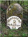
Old Milestone by the former A303, Holton parish
Metal plate attached to stone post by the UC road (was A303), Anchor Hill, in parish of HOLTON (SOUTH SOMERSET District), 400m East of Holton village, in lay-by in undergrowth, on South side of road. Wincanton iron plate, erected by the Wincanton turnpike trust in the 19th century.
Inscription reads:-
Wincanton
2
Ilcheſter
11
Grade II listed.
List Entry Number: 1274651 https://historicengland.org.uk/listing/the-list/list-entry/1274651
Milestone Society National ID: SO_WCIC02
Image: © Mike Faherty
Taken: 9 Dec 2008
0.22 miles


8

Direction Sign - Signpost on the B3145 at Shepherds Cross in Holton
Pyramid finial - 4 arms; Somerset SCC pyramid by the B3145, in parish of Holton (South Somerset District), on the north side of the crossroads on the B3145 at Shepherds Cross.
surveyed
Milestone Society National ID: SO_ST6826
Image: © Milestone Society
Taken: Unknown
0.25 miles