IMAGES TAKEN NEAR TO
Holton, WINCANTON, BA9 8AR
Introduction
This page details the photographs taken nearby to BA9 8AR by members of the Geograph project.
The Geograph project started in 2005 with the aim of publishing, organising and preserving representative images for every square kilometre of Great Britain, Ireland and the Isle of Man.

There are currently over 7.5m images from over14,400 individuals and you can help contribute to the project by visiting https://www.geograph.org.uk
Image Map
Images are licensed for reuse under creativecommons.org/licenses/by-sa/2.0
Notes
- Clicking on the map will re-center to the selected point.
- The higher the marker number, the further away the image location is from the centre of the postcode.
Image Listing (19 Images Found)
Images are licensed for reuse under creativecommons.org/licenses/by-sa/2.0
Image
Details
Distance
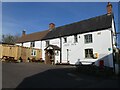
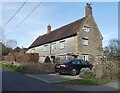
2
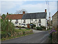
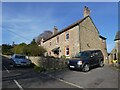
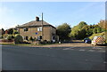
The Old Inn - Holton
400 year old coaching inn.
Image: © Mike Searle
Taken: 11 Apr 2007
0.04 miles
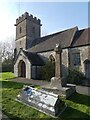
6
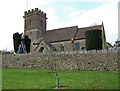
Churchyard Maintenance at Holton Church
"Are we in the way?" they asked as I took my picture. These folk were quite prepared to stop work and get out of picture, so I could have an unobstructed view of the church. Such gentlemen!
Image: © Mike Searle
Taken: 11 Apr 2007
0.08 miles

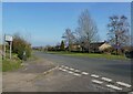
9
Truncated road near Holton
This road used to lead north from Holton village to Elliscombe House and Farm but it has been truncated by the building of the A303 and this is now a dead end.
Image: © Nigel Mykura
Taken: 16 Oct 2021
0.09 miles