IMAGES TAKEN NEAR TO
Shaftesbury Road, TEMPLECOMBE, BA8 0TD
Introduction
This page details the photographs taken nearby to Shaftesbury Road, BA8 0TD by members of the Geograph project.
The Geograph project started in 2005 with the aim of publishing, organising and preserving representative images for every square kilometre of Great Britain, Ireland and the Isle of Man.

There are currently over 7.5m images from over14,400 individuals and you can help contribute to the project by visiting https://www.geograph.org.uk
Image Map
Images are licensed for reuse under creativecommons.org/licenses/by-sa/2.0
Notes
- Clicking on the map will re-center to the selected point.
- The higher the marker number, the further away the image location is from the centre of the postcode.
Image Listing (5 Images Found)
Images are licensed for reuse under creativecommons.org/licenses/by-sa/2.0
Image
Details
Distance
1
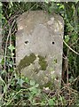
Old Milestone by the A30 near Bellman's Cross
Stone post (plate lost) by the A30, in parish of HENSTRIDGE (SOUTH SOMERSET District), 50m East of Bellman's Cross, in hedgerow, on South side of road. Sherbourne iron plate, erected by the Sherborne turnpike trust in the 19th century.
Inscription once read:-
(7)
(SHERBORNE)
(SHAFTESBURY)
(9)
Somerset HER listed.
HER number: 19642 https://www.heritagegateway.org.uk/Gateway/Results_Single.aspx?uid=19642&resourceID=100
Milestone Society National ID: SO_SBSH07.
Image: © M Faherty
Taken: 26 May 2007
0.13 miles
2

Direction Sign - Signpost by the A30, Bellman's Cross, Henstridge
Pyramid finial - 4 arms; Somerset SCC pyramid by the A30, in parish of Henstridge (South Somerset District), Bellman's Cross, on verge, Southwest corner of junction.
Lost before 2015.
Surveyed
Milestone Society National ID: SO_ST7320
Image: © Milestone Society
Taken: Unknown
0.17 miles

5

Restricted byway near Henstridge
The restricted byway takes you from Higher Marsh to Henstridge.
Image: © Maigheach-gheal
Taken: 30 Jun 2009
0.24 miles