IMAGES TAKEN NEAR TO
Summerfields, TEMPLECOMBE, BA8 0SZ
Introduction
This page details the photographs taken nearby to Summerfields, BA8 0SZ by members of the Geograph project.
The Geograph project started in 2005 with the aim of publishing, organising and preserving representative images for every square kilometre of Great Britain, Ireland and the Isle of Man.

There are currently over 7.5m images from over14,400 individuals and you can help contribute to the project by visiting https://www.geograph.org.uk
Image Map (Loading...)


Getting Data...Please wait
Leaflet Map data © OpenStreetMap
Images are licensed for reuse under creativecommons.org/licenses/by-sa/2.0
Notes
- Clicking on the map will re-center to the selected point.
- The higher the marker number, the further away the image location is from the centre of the postcode.
Image Listing (67 Images Found)
Images are licensed for reuse under creativecommons.org/licenses/by-sa/2.0
Image
Details
Distance
1

The Bird in Hand, Henstridge
The Bird in Hand on the corner of Blackmoor Lane opened in the mid 19th century.
Image: © Maigheach-gheal
Taken: 24 Feb 2008
0.04 miles
2
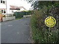
Help for hedgehogs
Henstridge has made great efforts to protect the diminishing creatures.
Image: © Neil Owen
Taken: 7 Jun 2023
0.05 miles
3

Sign for the Bird in Hand, Henstridge
A popular sign, usually from a family crest or some association with falconry.
Image: © Maigheach-gheal
Taken: 24 Feb 2008
0.05 miles
4

Substation on Blackmoor Lane
The small substation is off a footpath in the north of Henstridge. The path is an old one, being here long before this part of the village and the electricity network was developed in the late twentieth century.
Image: © Neil Owen
Taken: 7 Jun 2023
0.06 miles
5
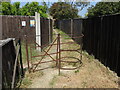
A relic on Blackmoor Lane
The north of Henstridge was once open fields with a few public paths running across them. Keeping the route after modern development, the path retains an old gate despite the rest of the environment.
Image: © Neil Owen
Taken: 7 Jun 2023
0.06 miles
6
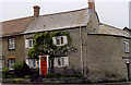
Typical stone cottage in the centre of Henstridge
Henstridge was a royal estate in the 10th century and was held by Earl Harold in 1066. This cottage is typical of those in the village.
Image: © M Etherington
Taken: 3 Apr 2006
0.11 miles

8

Lych gate, Henstridge
The gate was dedicated in 1921 in tribute to the men who fell in WWI. See VVVV for a look at a plaque under the tiles.
Image: © Neil Owen
Taken: 7 Jun 2023
0.15 miles
9

Plaque to the fallen in the lych gate
A list of the names of those who did not return is kept underneath the lych gate. See VVV for a location view.
Image: © Neil Owen
Taken: 7 Jun 2023
0.15 miles
10
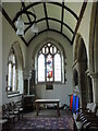
North aisle of St Nicholas
The church is an ancient place of worship, with traces of the original buildings of the twelfth and fourteenth centuries still evident.
Image: © Neil Owen
Taken: 7 Jun 2023
0.15 miles