1
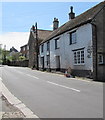
Pimpernel Cottage, Templecombe
On the west side of High Street. The typical chocolate-box depiction of a British cottage,
usually thatched, is only one type of cottage. In early 21st century UK usage,
a cottage can be anything from a humble shack to a grand mansion.
Image: © Jaggery
Taken: 13 May 2015
0.01 miles
2
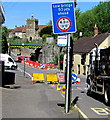
Low bridge 50 yards ahead, High Street, Templecombe
The headroom under the railway bridge http://www.geograph.org.uk/photo/4475628 is shown as 4 metres (13' 0").
Today, and for the next several weeks, there is also a 3 metres width limit ahead during roadworks.
Image: © Jaggery
Taken: 13 May 2015
0.02 miles
3
Templars Place, Templecombe
Modern flats on the west side of High Street.
Image: © Jaggery
Taken: 13 May 2015
0.02 miles
4
Templecombe United Reformed Church
Image: © Rude Health
Taken: 27 Mar 2015
0.02 miles
5
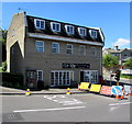
Tip Top, Templecombe
In May 2015, the hair & nail salon occupies the building on the corner of High Street and Station Road which formerly housed the village shop and post office.
Image: © Jaggery
Taken: 13 May 2015
0.03 miles
6
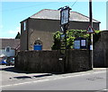
Templecombe United Reformed Church
The cramped location behind a wall made it difficult to get a good photo of this church set back from High Street.
I had to settle for this one which includes the name sign for the adjacent Templars Retreat. http://www.geograph.org.uk/photo/4474803
Image: © Jaggery
Taken: 13 May 2015
0.03 miles
7
Sign at "The Templars Retreat"
This public house was formerly known as "The Royal Wessex".
Image: © Shazz
Taken: 23 Sep 2012
0.04 miles
8
The Templars Retreat, Templecombe
Viewed across High Street from the corner of Station Road.
The pub was formerly named The Royal Wessex. http://www.geograph.org.uk/photo/666914
Image: © Jaggery
Taken: 13 May 2015
0.04 miles
9
Roadworks signs near the Templars Retreat, Templecombe
In May 2015, High Street roadworks reduce the road width on the left to 3 metres.
Temporary traffic lights maintain an alternating flow of one-way traffic past the roadworks.
Image: © Jaggery
Taken: 13 May 2015
0.04 miles
10
Sign for the Royal Wessex, Templecombe
Image: © Maigheach-gheal
Taken: 22 Jan 2008
0.04 miles


