IMAGES TAKEN NEAR TO
BA8 0DQ
Introduction
This page details the photographs taken nearby to BA8 0DQ by members of the Geograph project.
The Geograph project started in 2005 with the aim of publishing, organising and preserving representative images for every square kilometre of Great Britain, Ireland and the Isle of Man.

There are currently over 7.5m images from over14,400 individuals and you can help contribute to the project by visiting https://www.geograph.org.uk
Image Map (Loading...)


Getting Data...Please wait
Leaflet Map data © OpenStreetMap
Images are licensed for reuse under creativecommons.org/licenses/by-sa/2.0
Notes
- Clicking on the map will re-center to the selected point.
- The higher the marker number, the further away the image location is from the centre of the postcode.
Image Listing (21 Images Found)
Images are licensed for reuse under creativecommons.org/licenses/by-sa/2.0
Image
Details
Distance
1
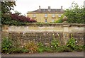
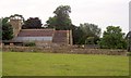
Horsington House
The C19 house http://list.english-heritage.org.uk/resultsingle.aspx?uid=1238176&searchtype=mapsearch was a Barnardos home, and subsequently a hotel; it is now divided into flats. The wall in the foreground, also shown in Image], is described at http://list.english-heritage.org.uk/resultsingle.aspx?uid=1274375&searchtype=mapsearch . See also Image
Image: © Derek Harper
Taken: 14 Sep 2013
0.00 miles
3
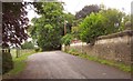
Road past Horsington House
A dead end, continuing past the church as a footpath to Abbas Combe. On the right is the 70-metre long boundary wall http://list.english-heritage.org.uk/resultsingle.aspx?uid=1274375&searchtype=mapsearch of Horsington House.
Image: © Derek Harper
Taken: 14 Sep 2013
0.05 miles
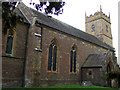
6
Church of St John the Baptist, Horsington
Seen from footpath WN 14/1 from Tower Hill. The church, also shown in Image, is mostly C19: "the interior is High Victorian" http://list.english-heritage.org.uk/resultsingle.aspx?uid=1238063&searchtype=mapsearch .
Image: © Derek Harper
Taken: 14 Sep 2013
0.06 miles
7
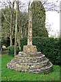
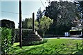
Old Market Cross at Horsington
A small plaque near the cross reads: 'This cross of Ham Hill stone, was once the scene of the village market. Possibly St. Aldhelm of Sherborne preached here (about 705 A.D.) before the church was built. It may have been erected on the grant of Free Warren to the Lord of the Manor in 1284, giving him the right to hold a fair, a market, and a court'. The cross is marked on the OS map, and is Grade II Listed.
Image: © Mike Searle
Taken: 11 Apr 2007
0.06 miles
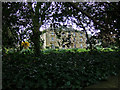
9
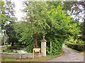
The lane to the church, Horsington
The lane also leads to Horsington House, hence the impressive pillar gatepost. With Duck Lane on the left and the duck pond in between.
Image: © Derek Harper
Taken: 14 Sep 2013
0.07 miles
10
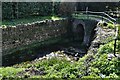
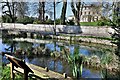
Horsington: The stream that runs through the village and small bridge over
Image: © Michael Garlick
Taken: 1 Apr 2019
0.08 miles