IMAGES TAKEN NEAR TO
Horsington, TEMPLECOMBE, BA8 0DJ
Introduction
This page details the photographs taken nearby to BA8 0DJ by members of the Geograph project.
The Geograph project started in 2005 with the aim of publishing, organising and preserving representative images for every square kilometre of Great Britain, Ireland and the Isle of Man.

There are currently over 7.5m images from over14,400 individuals and you can help contribute to the project by visiting https://www.geograph.org.uk
Image Map
Images are licensed for reuse under creativecommons.org/licenses/by-sa/2.0
Notes
- Clicking on the map will re-center to the selected point.
- The higher the marker number, the further away the image location is from the centre of the postcode.
Image Listing (6 Images Found)
Images are licensed for reuse under creativecommons.org/licenses/by-sa/2.0
Image
Details
Distance
1
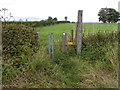
Stile near Horsington
The stile allows walkers access to the footpath that takes them towards Coombe Cross Farm.
Image: © Maigheach-gheal
Taken: 13 Aug 2011
0.13 miles
2
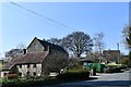
Horsington: Where Duck Lane joins the A357
Image: © Michael Garlick
Taken: 1 Apr 2019
0.22 miles
3
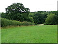
Field of clover near Horsington
A field of white clover near the village of Horsington.
Image: © Maigheach-gheal
Taken: 13 Aug 2011
0.23 miles
4
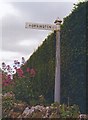
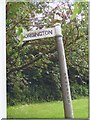
Old Direction Sign - Signpost by the A357, Higher Road, Horsington
Pyramid finial - 1 arm; Somerset SCC pyramid by the A357, in parish of Horsington (South Somerset District), opposite junction with northernmost of village lanes.
Surveyed
Milestone Society National ID: SO_ST6923A
Image: © Milestone Society
Taken: Unknown
0.23 miles

6
Old Direction Sign - Signpost by the A357, Horsington
Pyramid finial - 1 arm; Somerset SCC pyramid by the A357, in parish of Horsington (South Somerset District), junction with southern most of village lanes, by bus stop.
Surveyed
Milestone Society National ID: SO_ST6923B.
Image: © Milestone Society
Taken: Unknown
0.24 miles