IMAGES TAKEN NEAR TO
South Cheriton, TEMPLECOMBE, BA8 0BW
Introduction
This page details the photographs taken nearby to BA8 0BW by members of the Geograph project.
The Geograph project started in 2005 with the aim of publishing, organising and preserving representative images for every square kilometre of Great Britain, Ireland and the Isle of Man.

There are currently over 7.5m images from over14,400 individuals and you can help contribute to the project by visiting https://www.geograph.org.uk
Image Map (Loading...)


Getting Data...Please wait
Leaflet Map data © OpenStreetMap
Images are licensed for reuse under creativecommons.org/licenses/by-sa/2.0
Notes
- Clicking on the map will re-center to the selected point.
- The higher the marker number, the further away the image location is from the centre of the postcode.
Image Listing (6 Images Found)
Images are licensed for reuse under creativecommons.org/licenses/by-sa/2.0
Image
Details
Distance
1
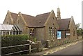
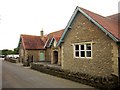
Horsington Church of England Primary School
The building dates from 1855-56 and is described at http://list.english-heritage.org.uk/resultsingle.aspx?uid=1238115&searchtype=mapsearch . It must be difficult to teach and learn a C21 curriculum in a building designed for a different era.
Image: © Derek Harper
Taken: 14 Sep 2013
0.01 miles
2
Horsington Church of England Primary School
A view of Image] from down the road.
Image: © Derek Harper
Taken: 14 Sep 2013
0.01 miles
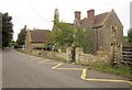
3
Lower Road, Peckholds Ash
The lower road between South Cheriton and Horsington (the higher is the A357) passes the war memorial, behind which is a car park, and approaches Horsington School.
Image: © Derek Harper
Taken: 14 Sep 2013
0.03 miles
4
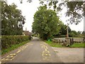
Monarch's Way near South Cheriton
With the A357 Higher Road a little behind the camera, the Way follows footpath WN 14/4 across a wide field to meet Lower Road. On the left is the Cemetery Chapel at South Cheriton.
Image: © Derek Harper
Taken: 14 Sep 2013
0.18 miles
5
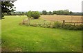
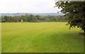
Farmland near Horsington
From beside Lower Road next to St Margaret's Hall, with a playing field on the left.
Image: © Derek Harper
Taken: 14 Sep 2013
0.19 miles
6
St Margaret?s Hall, Horsington
Horsington Village Hall, as it is also known, was built in 1907.
Image: © Derek Harper
Taken: 14 Sep 2013
0.22 miles