IMAGES TAKEN NEAR TO
The Cloisters, Church Lane, GLASTONBURY, BA6 9NL
Introduction
This page details the photographs taken nearby to The Cloisters, Church Lane, BA6 9NL by members of the Geograph project.
The Geograph project started in 2005 with the aim of publishing, organising and preserving representative images for every square kilometre of Great Britain, Ireland and the Isle of Man.

There are currently over 7.5m images from over14,400 individuals and you can help contribute to the project by visiting https://www.geograph.org.uk
Image Map
Images are licensed for reuse under creativecommons.org/licenses/by-sa/2.0
Notes
- Clicking on the map will re-center to the selected point.
- The higher the marker number, the further away the image location is from the centre of the postcode.
Image Listing (569 Images Found)
Images are licensed for reuse under creativecommons.org/licenses/by-sa/2.0
Image
Details
Distance
1
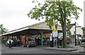
Railway canopy, former Somerset Railway
Rescued goods platform canopy, re-sited in St John's car park and sheltering a farmers' market today.
The service between Glastonbury and Highbridge began in 1854 following the closure of the bankrupt canal. In 1862 it became the Somerset and Dorset Railway, extending to Burnham, Cole and Wells and eventually to Bath. It closed in 1966 under Dr Beeching's axe.
The Western relief road now follows part of the railway line route.
Image: © Pauline E
Taken: 24 May 2009
0.02 miles
2
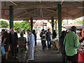
Farmers' market, Glastonbury
Under the old railway canopy of the former Somerset Railway.
The rescued goods platform canopy, re-sited in St John's car park is sheltering a farmers' market today.
The service between Glastonbury and Highbridge began in 1854 following the closure of the bankrupt canal. In 1862 it became the Somerset and Dorset Railway, extending to Burnham, Cole and Wells and eventually to Bath. It closed in 1966 under Dr Beeching's axe.
The Western relief road now follows part of the railway line route.
Image: © Pauline E
Taken: 24 May 2009
0.02 miles
3
Entrance to the Daisy Centre
An angelic healing retreat. Glastonbury appears to have a concentration of establishments of this genre.
Image: © Bill Boaden
Taken: 29 Dec 2016
0.02 miles
4

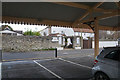
Re-erected station canopy, Glastonbury
Moved from the former station site and re-erected to provide shelter for traders.
Image: © Chris Allen
Taken: 30 Jun 2012
0.02 miles
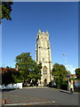
5
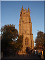
The Church of St John the Baptist
In the early autumn evening sun
Image: © John Finch
Taken: 16 Sep 2010
0.03 miles
6
Church of St John the Baptist, Glastonbury
Image: © PAUL FARMER
Taken: 27 Aug 2015
0.03 miles
7

A slice taken out
A corrugated shed, somewhat out of place in the more modern surrounds of the car park, with an odd angle to its dimensions. However, the side of it look rather different - see Image
Image: © Neil Owen
Taken: 18 Sep 2012
0.03 miles
8
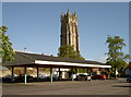
Looking down on the changing face of the town
St John's tower in the background can remember when this car park was a busy market. However, the railway canopy is an interloper from the old station a couple of miles to the west. The original line closed after Dr Beeching wielded his axe but the canopy of the steamy goods station was relocated here in 1984.
Image: © Neil Owen
Taken: 18 Sep 2012
0.03 miles
9
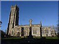
Church of St John the Baptist, Glastonbury
Image: © Becky Williamson
Taken: 9 Jan 2015
0.03 miles
10
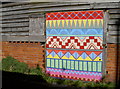
A mixture of styles and patterns
The side of a corrugated shed has a different form: among the brick and wood is a strikingly painted door. See Image] for the frontal view.
Image: © Neil Owen
Taken: 18 Sep 2012
0.03 miles