IMAGES TAKEN NEAR TO
Northload Bridge, GLASTONBURY, BA6 9LF
Introduction
This page details the photographs taken nearby to Northload Bridge, BA6 9LF by members of the Geograph project.
The Geograph project started in 2005 with the aim of publishing, organising and preserving representative images for every square kilometre of Great Britain, Ireland and the Isle of Man.

There are currently over 7.5m images from over14,400 individuals and you can help contribute to the project by visiting https://www.geograph.org.uk
Image Map
Images are licensed for reuse under creativecommons.org/licenses/by-sa/2.0
Notes
- Clicking on the map will re-center to the selected point.
- The higher the marker number, the further away the image location is from the centre of the postcode.
Image Listing (19 Images Found)
Images are licensed for reuse under creativecommons.org/licenses/by-sa/2.0
Image
Details
Distance
1
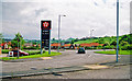
Roundabout junction of A39 and A361 roads, near site of Glastonbury station
View NE, to Glastonbury Tor in the distance. Glastonbury & Street station had been 100-200 yards behind here and the ex-Somerset & Dorset line, Burnham-on-Sea - Highbridge - Evercreech Junction (closed 7/3/66), would have run along on the left, also throwing off a branch to Wells (closed 29/10/51) to the left just ahead. Note the price of petrol in 2001.
Image: © Ben Brooksbank
Taken: 16 May 2001
0.03 miles
2
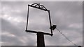
Sign of the Times
Post and frame for the pub sign of the former First & Last.
Image: © Stewart Marsh
Taken: 3 Jul 2018
0.05 miles
3
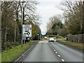
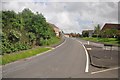
A39, Glastonbury Bypass
The Glastonbury Bypass opened in the late 1990s, here it is approaching Northload Bridge Roundabout.
Image: © David Dixon
Taken: 10 Dec 2013
0.07 miles
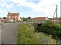
4
Former First & Last Pub
A view of the road towards Meare at Northload Bridge, showing the former First & Last public house. The pole and frame for its old pub sign still stands:- Image
Image: © Stewart Marsh
Taken: 3 Jul 2018
0.07 miles
5
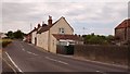
Glastonbury : Northload Street
Looking along Northload Street in Glastonbury from a roundabout on the A39.
Image: © Lewis Clarke
Taken: 15 Jun 2012
0.09 miles
7
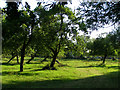
Orchard next to the Abbey Moor Stadium, Glastonbury
This orchard is part of a farm between Godney Road and the A39, south of the Abbey Moor Stadium.
Image: © Jim Champion
Taken: 7 Aug 2006
0.14 miles
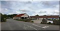
9
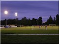
Glastonbury FC at the Abbey Moor Stadium
The Abbey Moor Stadium is to the northwest of Glastonbury, alongside the road to Godney. The football club moved here in 1982 where the floodlit pitch was surrounded by a greyhound track (visible in the foreground) until the summer of 2000.
Image: © Jim Champion
Taken: 7 Aug 2006
0.15 miles
10
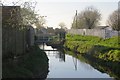
Mill Stream
Running off the Brue alongside Meare Road, Glastonbury.
Image: © Richard Webb
Taken: 6 Apr 2015
0.18 miles