IMAGES TAKEN NEAR TO
Mayfield Close, GLASTONBURY, BA6 9GU
Introduction
This page details the photographs taken nearby to Mayfield Close, BA6 9GU by members of the Geograph project.
The Geograph project started in 2005 with the aim of publishing, organising and preserving representative images for every square kilometre of Great Britain, Ireland and the Isle of Man.

There are currently over 7.5m images from over14,400 individuals and you can help contribute to the project by visiting https://www.geograph.org.uk
Image Map
Images are licensed for reuse under creativecommons.org/licenses/by-sa/2.0
Notes
- Clicking on the map will re-center to the selected point.
- The higher the marker number, the further away the image location is from the centre of the postcode.
Image Listing (587 Images Found)
Images are licensed for reuse under creativecommons.org/licenses/by-sa/2.0
Image
Details
Distance
1
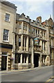
The George & Pilgrims Hotel, Glastonbury
Hotel with 14 en-suite bedrooms, located at 1 High Street.
Its is reputed to be the oldest purpose-built inn in the southwest of England. It was built in 1475 to provide hospitality for visitors to the nearby Benedictine abbey.
Image: © Jaggery
Taken: 7 Jul 2010
0.03 miles
2
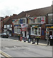
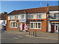
The Market House Inn, Glastonbury
Bar and restaurant with accommodation, located on Magdalene Street.
Image: © Jaggery
Taken: 7 Jul 2010
0.03 miles
3
Glastonbury - The Market House Inn
The Market House inn on Magdalene Street.
Image: © Chris Talbot
Taken: 15 Oct 2011
0.03 miles
4
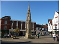
Glastonbury - Market Cross
This market cross was erected in 1846 to replace an earlier mediaeval cross that was removed in 1806, The cross was refurbished in 2005 as part of the 300th anniversary of the town.
Image: © Chris Talbot
Taken: 15 Oct 2011
0.03 miles
5
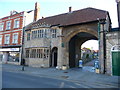
Glastonbury - The Entrance To Glastonbury Abbey
Going under this archway leads you into the peaceful grounds of the abbey, away from the busy town outside.
Image: © Chris Talbot
Taken: 15 Oct 2011
0.03 miles
6
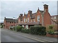
Almshouses, Heritage Court, Glastonbury
Four almshouses with a very steep roof. The inscription on the badge reads: Erected in memory of Rebecca Austin who died at the Abbey January 15th 1887 by her husband James Austin Mayor of Glastonbury. The date 1887 appears below the badge
Image: © David Smith
Taken: 16 Nov 2017
0.04 miles
7
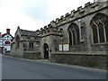
St Benedict's Church, Glastonbury
Side view of Image
Image: © Steve Barnes
Taken: 5 Feb 2011
0.04 miles
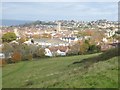
9
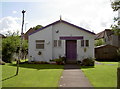
Residence for the deity
'The Goddess Hall' opposite St Benedict's church, with its jaunty purple colour scheme and a slender sapling wrapped in decorative material.
Image: © Neil Owen
Taken: 18 Sep 2012
0.05 miles
10
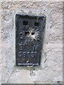
Ordnance Survey Flush Bracket (S6031)
This OS flush Bracket can be found on St Benedict's Church. It marks a point 45.483ft above mean sea level.
Image: © Adrian Dust
Taken: 21 Nov 2014
0.05 miles