IMAGES TAKEN NEAR TO
Street Road, GLASTONBURY, BA6 9EF
Introduction
This page details the photographs taken nearby to Street Road, BA6 9EF by members of the Geograph project.
The Geograph project started in 2005 with the aim of publishing, organising and preserving representative images for every square kilometre of Great Britain, Ireland and the Isle of Man.

There are currently over 7.5m images from over14,400 individuals and you can help contribute to the project by visiting https://www.geograph.org.uk
Image Map
Images are licensed for reuse under creativecommons.org/licenses/by-sa/2.0
Notes
- Clicking on the map will re-center to the selected point.
- The higher the marker number, the further away the image location is from the centre of the postcode.
Image Listing (72 Images Found)
Images are licensed for reuse under creativecommons.org/licenses/by-sa/2.0
Image
Details
Distance
1
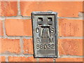
Ordnance Survey Flush Bracket S6032
This can be found on the wall of The Drill Hall.
For more detail see : http://www.bench-marks.org.uk/bm18952
Image: © Peter Wood
Taken: 30 Mar 2014
0.01 miles
2
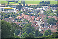
Glastonbury : Town Scenery
Looking down into the town of Glastonbury.
Image: © Lewis Clarke
Taken: 22 Jul 2015
0.01 miles
3
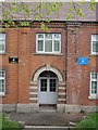
Entrance to the Barracks
Entrance to the ATC building along the Street Road in Glastonbury
Image: © Bill Nicholls
Taken: 14 Apr 2012
0.02 miles
4
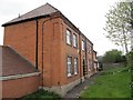
ATC building in Glastonbury
The ATC building in Glastonbury, you can see the benchmark on the lower right of the building.
Image: © Bill Nicholls
Taken: 14 Apr 2012
0.02 miles
5
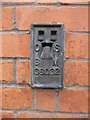
Benchmark on the ATC Barracks
Close up of the benchmark on the ATC barracks along Street Road in Glastonbury.
Image: © Bill Nicholls
Taken: 14 Apr 2012
0.03 miles
6
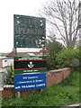
The Speaking Tree
Not sure where it was but the sign is very faded now.
Image: © Bill Nicholls
Taken: 14 Apr 2012
0.03 miles
7
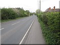
The A361 Street Road
The A361 Street Road looking towards Street.
Image: © Bill Nicholls
Taken: 14 Apr 2012
0.04 miles
8
Entrance to the yard
Entrance to the yard at the ATC barracks in Glastonbury.
Image: © Bill Nicholls
Taken: 14 Apr 2012
0.04 miles
9
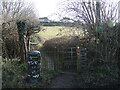
Wirral Park footpath
The path goes up Wearyall (or Wirrall) Hill. Some old style fencing is met by modern galvanised.
Image: © Neil Owen
Taken: 1 Feb 2024
0.05 miles
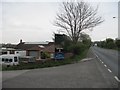
10
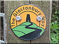
The Glastonbury Way
Footpath waymarker at the foot of Wearyall Hill in Glastonbury.
Image: © Colin Smith
Taken: 28 Mar 2022
0.05 miles