IMAGES TAKEN NEAR TO
High Street, GLASTONBURY, BA6 9DZ
Introduction
This page details the photographs taken nearby to High Street, BA6 9DZ by members of the Geograph project.
The Geograph project started in 2005 with the aim of publishing, organising and preserving representative images for every square kilometre of Great Britain, Ireland and the Isle of Man.

There are currently over 7.5m images from over14,400 individuals and you can help contribute to the project by visiting https://www.geograph.org.uk
Image Map
Images are licensed for reuse under creativecommons.org/licenses/by-sa/2.0
Notes
- Clicking on the map will re-center to the selected point.
- The higher the marker number, the further away the image location is from the centre of the postcode.
Image Listing (478 Images Found)
Images are licensed for reuse under creativecommons.org/licenses/by-sa/2.0
Image
Details
Distance
1
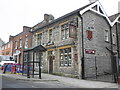
Ye Queen's Head, High Street, Glastonbury
Image: © Roger Cornfoot
Taken: 27 Jan 2010
0.01 miles
2
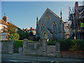
Glastonbury Methodist Church
Located on Lambrook Street, viewed from the eastern end of High Street.
Near the apex of the ornate drinking fountain, http://www.geograph.org.uk/photo/1250671 a hand points to the right (south). Around the hand is inscribed TO THE TOR.
Image: © Jaggery
Taken: 7 Jul 2010
0.01 miles
3
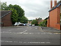
Butt Close, Glastonbury
The eastern end of Butt Close, viewed across Wells Road. 'Close' is inaccurate, because the far end connects with The Archers Way.
Image: © Jaggery
Taken: 7 Jul 2010
0.01 miles
4
Glastonbury - Ye Queens Head
Another pub for sale in this tough business.
Image: © Chris Talbot
Taken: 15 Oct 2011
0.01 miles
5
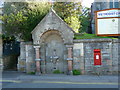
Glastonbury - Drinking Fountain
Over the years this fountain would have quenched the thirst of many travellers as they make their way to Glastonbury Tor.
Image: © Chris Talbot
Taken: 15 Oct 2011
0.01 miles
6
Glastonbury - Methodist Church
Glastonbury Methodist church is located on Lambrook Street.
Image: © Chris Talbot
Taken: 15 Oct 2011
0.01 miles
7
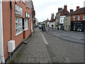
Looking west-southwest along the High Street
With the tower of the church of St John the Baptist visible in the distance.
Image: © John Baker
Taken: 4 Apr 2016
0.01 miles
8
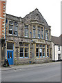
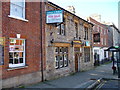
Avalon Conservative Club
High Street, Glastonbury.
Image: © Pauline E
Taken: 24 May 2009
0.01 miles
9
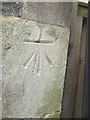
Ordnance Survey Cut Mark
This OS cut mark can be found on the east face of the Congregational Chapel on High Street. It marks a point 29.081m above mean sea level.
Image: © Adrian Dust
Taken: 21 Nov 2014
0.01 miles
10
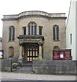
Glastonbury United Reformed Church
Re-built in 1814 with a 1898 portico.
This is on the site of the Ship Inn, where Glastonbury's dissenters settled after leaving the parish church when Charles II was restored to the throne.
Image: © Pauline E
Taken: 24 May 2009
0.01 miles