IMAGES TAKEN NEAR TO
Piltown, GLASTONBURY, BA6 8NQ
Introduction
This page details the photographs taken nearby to Piltown, BA6 8NQ by members of the Geograph project.
The Geograph project started in 2005 with the aim of publishing, organising and preserving representative images for every square kilometre of Great Britain, Ireland and the Isle of Man.

There are currently over 7.5m images from over14,400 individuals and you can help contribute to the project by visiting https://www.geograph.org.uk
Image Map
Images are licensed for reuse under creativecommons.org/licenses/by-sa/2.0
Notes
- Clicking on the map will re-center to the selected point.
- The higher the marker number, the further away the image location is from the centre of the postcode.
Image Listing (6 Images Found)
Images are licensed for reuse under creativecommons.org/licenses/by-sa/2.0
Image
Details
Distance
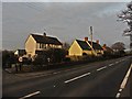
1
The A361 and part of Manor Farm, Piltown
How much is Piltown confused with Pilton, a short distance down the road?
Image: © HelenK
Taken: 26 Sep 2007
0.05 miles
2
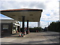
Piltown Filling Station
An independent filling station with a pantiled canopy. There is some history here: http://www.patrick-graham.co.uk/piltown-filling-station/
Image: © HelenK
Taken: 26 Sep 2007
0.08 miles
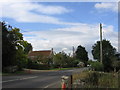
4
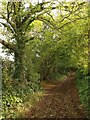
Cottles Lane, West Pennard
The lane climbs Pennard Hill, petering out into a byway. The old route is slearly preserved in rights of way along the ridge.
Image: © Derek Harper
Taken: 24 Oct 2008
0.22 miles
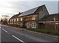
5
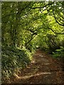
Cottles Lane, West Pennard
A little further up the gentle hill from Image
Image: © Derek Harper
Taken: 24 Oct 2008
0.23 miles