IMAGES TAKEN NEAR TO
Sandpits Road, GLASTONBURY, BA6 8EH
Introduction
This page details the photographs taken nearby to Sandpits Road, BA6 8EH by members of the Geograph project.
The Geograph project started in 2005 with the aim of publishing, organising and preserving representative images for every square kilometre of Great Britain, Ireland and the Isle of Man.

There are currently over 7.5m images from over14,400 individuals and you can help contribute to the project by visiting https://www.geograph.org.uk
Image Map
Images are licensed for reuse under creativecommons.org/licenses/by-sa/2.0
Notes
- Clicking on the map will re-center to the selected point.
- The higher the marker number, the further away the image location is from the centre of the postcode.
Image Listing (14 Images Found)
Images are licensed for reuse under creativecommons.org/licenses/by-sa/2.0
Image
Details
Distance
1
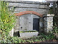
An old pump on the Old Wells Road
Old maps show a pump on this spot, which has been largely covered up, but the spout and a trough are useful indicators.
Image: © Neil Owen
Taken: 20 Dec 2022
0.02 miles
2
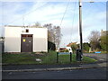
Substation on Chinnock Road
This part of Glastonbury is a twentieth century development, along with the necessary infrastructure. Beyond, on the Old Wells Road is an old water pump - see Image
Image: © Neil Owen
Taken: 20 Dec 2022
0.03 miles
3
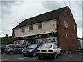
Glastonbury: Windmill Hill Post Office
This post office, at 7 Chinnock Road, will close down on 7 July 2008, one of 2,500 nationally to close this year.
Image: © Chris Downer
Taken: 20 Jun 2008
0.05 miles
4
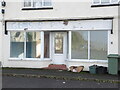
Closed on Chinnock Road
A shop seems to have been closed for some time. It was an antiques shop but prior to that was Gem's Scrapstore - and the sign still shows.
Image: © Neil Owen
Taken: 20 Dec 2022
0.06 miles
5
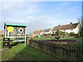
Windmill Batch open space
A large greenspace on Chinnock Road and Whiting Road offers recreation and enjoyment for all, but especially for younger ones. It is interesting to note that, with the twentieth century development, part of Edmund Hill Lane was mettaled and renamed Whiting Road.
Image: © Neil Owen
Taken: 20 Dec 2022
0.07 miles
6
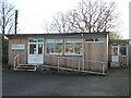
St Edmund's Community Hall
The small hall buildings are based on Portacabins and received grants of £50,000 last year to renovate them.
Image: © Neil Owen
Taken: 20 Dec 2022
0.07 miles
7
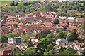
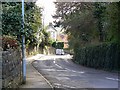
Glastonbury : Town Scenery
Looking down towards the town of Glastonbury.
Image: © Lewis Clarke
Taken: 22 Jul 2015
0.16 miles
8
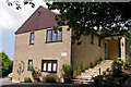
Chestnuts Boutique Bed & Breakfast, Glastonbury
Image: © Chris Lee
Taken: 3 Aug 2006
0.20 miles
9
Bove Town, Glastonbury
This residential road leads to Wells Road, which once was the main route through Glastonbury until the A39 bypass was built. The viewpoint is at the junction between Bove Town and Wick Hollow.
Image: © Brian Robert Marshall
Taken: 19 Mar 2008
0.22 miles
10
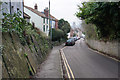
Bove Town
A descent towards Glastonbury town centre with the tower of St John's Church ahead.
Image: © Bill Boaden
Taken: 29 Dec 2016
0.22 miles