IMAGES TAKEN NEAR TO
Bath Road, WELLS, BA5 3EW
Introduction
This page details the photographs taken nearby to Bath Road, BA5 3EW by members of the Geograph project.
The Geograph project started in 2005 with the aim of publishing, organising and preserving representative images for every square kilometre of Great Britain, Ireland and the Isle of Man.

There are currently over 7.5m images from over14,400 individuals and you can help contribute to the project by visiting https://www.geograph.org.uk
Image Map (Loading...)


Getting Data...Please wait
Leaflet Map data © OpenStreetMap
Images are licensed for reuse under creativecommons.org/licenses/by-sa/2.0
Notes
- Clicking on the map will re-center to the selected point.
- The higher the marker number, the further away the image location is from the centre of the postcode.
Image Listing (37 Images Found)
Images are licensed for reuse under creativecommons.org/licenses/by-sa/2.0
Image
Details
Distance
1
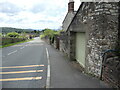
Looking down the B3139 Bath Road
Follow this road downhill and you will be in Wells before too long. On the left is the village of South Horrington, where there used to be a large mental health facility of the past. The building on the right is Birdwood House, once a nurses' residence. On it is a benchmark - see Image
Image: © Neil Owen
Taken: 26 May 2021
0.01 miles
2
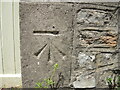
Benchmark on Birdwood House
A cutmark on the end wall of a house garage on the B3139: see https://www.bench-marks.org.uk/bm149677 for the entry in the Benchmark Database and Image] for a wider look down the hill.
Image: © Neil Owen
Taken: 26 May 2021
0.01 miles
3
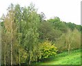
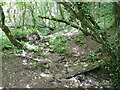
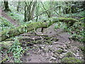
Trees in the valley
This photograph shows the route of the footpath which runs from West Horrington south to the main Wells-Bath road. The footpath follows the line of the wooded valley shown.
Image: © Sharon Loxton
Taken: 6 Oct 2007
0.06 miles
4
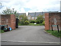
The Orchards on Upper Breach
This site was the old isolation hospital, part of the old Mendip hospital site. In 1848 the designer Sir George Gilbert Scott penned a magnificent health facility here to treat many mental health sufferers. Today the site is converted to residential and some commercial use.
Image: © Neil Owen
Taken: 26 May 2021
0.11 miles
5
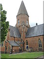
A saintly home
When built, this was a Church of England chapel that served the original Somerset and Bath Pauper Lunatic Asylum. Along with much of the hospital wings, it was designed by George Scott and William Moffatt in the Gothic Revival style. Following closure in 1991, the church was converted into residential use and renamed St Cuthbert's Village.
Image: © Neil Owen
Taken: 26 May 2021
0.15 miles
6
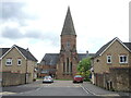
The church from Upper Breach
Gilbert Scott and William Moffatt designed the hospital site with this impressive church at the centre in the 1840s.
Image: © Neil Owen
Taken: 26 May 2021
0.15 miles
7
Coming down from the high Mendips
A stream runs from the upper slopes around Pen Hill and drops through Biddle Combe. Along its way down the stream follows a wooded valley and joins forces with others.
Image: © Neil Owen
Taken: 26 May 2021
0.15 miles
8
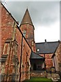
Former chapel at Somerset and Bath Pauper Lunatic Asylum
Converted into apartments.
Image: © Roger Cornfoot
Taken: 17 Aug 2020
0.16 miles
9
Across a dry stream
The fallen trunk is draped with all manner of mosses and lichens, indicating how moist and luscious the woodland valley normally is. However, the recent Spring conditions were more like a drought and hardly any water is now flowing under the lumber.
Image: © Neil Owen
Taken: 26 May 2021
0.16 miles
10
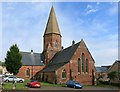
Former Church, South Horrington
This church was at the centre of the former Mendip Hospital which closed in 1991.
The hospital opened in 1848 and much of the design was by George Gilbert Scott.
Following closure many of the buildings have been converted into housing, including the church, creating an unusual and attractive new small village.
Image: © Des Blenkinsopp
Taken: 26 Aug 2014
0.16 miles