IMAGES TAKEN NEAR TO
Bath Road, WELLS, BA5 3EG
Introduction
This page details the photographs taken nearby to Bath Road, BA5 3EG by members of the Geograph project.
The Geograph project started in 2005 with the aim of publishing, organising and preserving representative images for every square kilometre of Great Britain, Ireland and the Isle of Man.

There are currently over 7.5m images from over14,400 individuals and you can help contribute to the project by visiting https://www.geograph.org.uk
Image Map
Images are licensed for reuse under creativecommons.org/licenses/by-sa/2.0
Notes
- Clicking on the map will re-center to the selected point.
- The higher the marker number, the further away the image location is from the centre of the postcode.
Image Listing (11 Images Found)
Images are licensed for reuse under creativecommons.org/licenses/by-sa/2.0
Image
Details
Distance
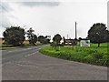
2

2011 : B3139 Bath Road heading south west toward Wells
First Direct service bus 173 to Bath nears the top of the hill out of Wells.
Image: © Maurice Pullin
Taken: 24 Oct 2011
0.10 miles
3
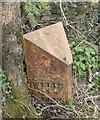
Old Milepost by the B3139, Bath Road, St Cuthbert Out Parish
Cast iron post by the B3139, in parish of St Cuthbert Out (Mendip District), South West of Slab House Inn, in front of boundary wall, on verge, on South side of road. Plated iron casting, erected by the Wells turnpike trust in the 19th century.
Inscription reads:-
: WELLS / 3 / MILES : : BATH / 17 / MILES :
Grade II listed. List Entry Number: 1345152
https://historicengland.org.uk/listing/the-list/list-entry/1345152
Milestone Society National ID: SO_BAWL17
Image: © Mike Faherty
Taken: 2 Apr 2009
0.10 miles
4

Old Milestone, B3139, Bath Road, Haydon
The milestone is locate south west of the Slab House Inn, in front of the boundary wall on the verge on the south side of the road. Parish of St Cuthbert Out (Mendip District). Cast iron post, Plated iron casting design, erected by the Wells turnpike trust in the 19th century.
Inscription reads:-
WELLS / 3 / MILES : : BATH / 17 / MILES
Grade II listed. List Entry Number: 1345152
https://historicengland.org.uk/listing/the-list/list-entry/1345152
Milestone Society National ID: SO_BAWL17
Image: © Janet Dowding
Taken: 24 Mar 2004
0.10 miles
5
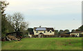
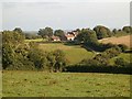
2011 : Park Farm, Haydon
At the eastern end of Horrington Hill.
Image: © Maurice Pullin
Taken: 24 Oct 2011
0.12 miles
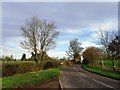
6
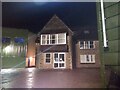
2011 : Cottage at the foot of Horrington Hill
The inviting track is not a public footpath, the notice on the right reinforces this.
The B3139 Bath Road passes the door.
Image: © Maurice Pullin
Taken: 24 Oct 2011
0.13 miles
8
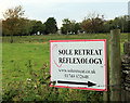
2011 : Reflexology on the Mendips
A sign which caught my eye on Haydon Drove.
No personal experience of it, information here: http://www.soleretreat.co.uk/
Dare I do it? Yes, go on, be a devil http://www.youtube.com/watch?v=d_mLFHLSULw&feature=related
Image: © Maurice Pullin
Taken: 24 Oct 2011
0.18 miles
10
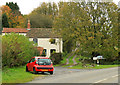
Haydon House
View from Haydon Drove.
Image: © Patrick Mackie
Taken: 27 Aug 2006
0.19 miles