IMAGES TAKEN NEAR TO
Gilbert Scott Road, WELLS, BA5 3BW
Introduction
This page details the photographs taken nearby to Gilbert Scott Road, BA5 3BW by members of the Geograph project.
The Geograph project started in 2005 with the aim of publishing, organising and preserving representative images for every square kilometre of Great Britain, Ireland and the Isle of Man.

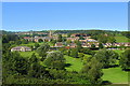
There are currently over 7.5m images from over14,400 individuals and you can help contribute to the project by visiting https://www.geograph.org.uk
Image Map
Images are licensed for reuse under creativecommons.org/licenses/by-sa/2.0
Notes
- Clicking on the map will re-center to the selected point.
- The higher the marker number, the further away the image location is from the centre of the postcode.
Image Listing (36 Images Found)
Images are licensed for reuse under creativecommons.org/licenses/by-sa/2.0
Image
Details
Distance
1
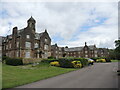
From Gilbert Scott Road
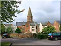
Now modernised as housing, the former Mendip hospital still has a sense of grandeur and style. Indeed, the conversion of the complex has been named as the village of St Cuthbert Out.
Image: © Neil Owen
Taken: 26 May 2021
0.06 miles
2
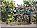
Gilbert Scott Road
The famed Sir George designed the former Mendip hospital in this site. However, the road name sign is somewhat askew: the white lettering appears to overlay darker shapes - some of which are definitely not in the correct alignment.
Image: © Neil Owen
Taken: 26 May 2021
0.06 miles
3
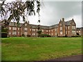
Former Somerset and Bath Pauper Lunatic Asylum
Converted to apartments in 1991.
Image: © Roger Cornfoot
Taken: 17 Aug 2020
0.07 miles
4
The Mendip Hospital, South Horrington. Nr Wells
This beautiful building on the outskirts of Wells catered for people suffering from mental illnesses. It closed in the 1980s and subsequently has been turned into apartments, increasing the population of South Horrington dramatically.
Image: © Sharon Loxton
Taken: 2 Jun 2006
0.09 miles
5
South Horrington
From Wells Golf Club looking towards the expanding village of South Horrington. Originally South Horrington consisted of a few houses (seen on the right of the photo) along the road and Mendip Hospital (an asylum). The hospital was redeveloped into housing some years ago, and the area is now a thriving little community. The crane shows where new housing (apparently sheltered accommodation) is now being erected.
Image: © Sharon Loxton
Taken: 24 Aug 2007
0.09 miles
6
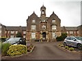
Somerset and Bath Pauper Lunatic Asylum
Now apartments.
Image: © Roger Cornfoot
Taken: 17 Aug 2020
0.09 miles
7
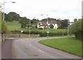
Old Frome Road near South Horrington
Some of the new housing close to the road east of Wells. The road to the left is called Gilbert Scott Road, acknowledging the famous Victorian architect who jointly designed the former Mendip Hospital to which the road leads.
Image: © Derek Harper
Taken: 16 Aug 2011
0.11 miles
8
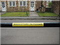
Beware of traffic - no pavement
Two things to alarm a casual pedestrian.
Image: © Neil Owen
Taken: 26 May 2021
0.12 miles
9
Old Buildings, New Housing
This is part of the site of the former Mendip Hospital which closed in 1991.
The hospital opened in 1848 and much of the design was by George Gilbert Scott.
Following closure many of the buildings have been converted into housing, including the church, creating an unusual and attractive new small village.
Image: © Des Blenkinsopp
Taken: 26 Aug 2014
0.12 miles
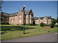
10
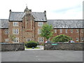
A courtyard behind the old hospital
South Horrington was the site of the old Somerset and Bath Pauper Lunatic Asylum from 1848. Scott and Moffatt were afforded quite a lot of freedom to create a grand institution, with imposing buildings and pots of open spaces. After many patients, it finally closed its wings in 1991. Today the site is residential but much of the original details are retained.
Image: © Neil Owen
Taken: 26 May 2021
0.12 miles