IMAGES TAKEN NEAR TO
Milton, WELLS, BA5 3AQ
Introduction
This page details the photographs taken nearby to BA5 3AQ by members of the Geograph project.
The Geograph project started in 2005 with the aim of publishing, organising and preserving representative images for every square kilometre of Great Britain, Ireland and the Isle of Man.

There are currently over 7.5m images from over14,400 individuals and you can help contribute to the project by visiting https://www.geograph.org.uk
Image Map
Images are licensed for reuse under creativecommons.org/licenses/by-sa/2.0
Notes
- Clicking on the map will re-center to the selected point.
- The higher the marker number, the further away the image location is from the centre of the postcode.
Image Listing (26 Images Found)
Images are licensed for reuse under creativecommons.org/licenses/by-sa/2.0
Image
Details
Distance
2
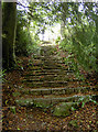
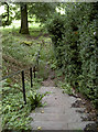
Rustic steps through the estate
A footpath runs down the Mendips and through the estate of Milton Lodge. Thoughtfully, this flight of steps aids travellers and is suitably styled.
Image: © Neil Owen
Taken: 6 Sep 2017
0.10 miles
3
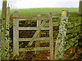
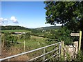
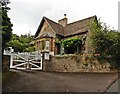
Gate above Milton Lodge
The footpath enters the grounds of the private estate. The path simply cuts across the bend in the road near to Walcombe.
Image: © Neil Owen
Taken: 6 Sep 2017
0.10 miles
4
Down to the Old Bristol Road
The footpath carries on through the Milton Lodge estate and on to the outskirts of Wells.
Image: © Neil Owen
Taken: 6 Sep 2017
0.11 miles
5
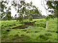
Sunken history
Just discernible are three arms of a pond. It is a triple entry cattle pond that appears to be unique in the Mendips and is thought to date from the late 1700s. It is sited to catch the rainwaters running down the slopes and is also connected to other ponds elsewhere by underground channels.
Image: © Neil Owen
Taken: 6 Sep 2017
0.12 miles
7
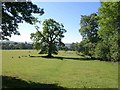
Oak near Milton Lodge
Footpath WS 10/14H crosses this field past Milton Lodge Gardens (right) towards the Old Bristol Road north of Wells. The field with its scattered trees forms part of the park associated with Milton Lodge http://webapp1.somerset.gov.uk/her/details.asp?prn=25450 .
Image: © Derek Harper
Taken: 17 Jun 2010
0.14 miles
9
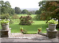
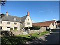
A magnificent view
When this part of the southern slopes of the Mendips was first occupied in the 1700s the terraces were hewn out of the limestone, allowing some fine landscaping. What was farmland became a home to a wealthy family and they afforded a wonderful panorama over the city of Wells and most of north Somerset - the cathedral can be seen in the distance. Mature trees complement the view beautifully.
Image: © Neil Owen
Taken: 6 Sep 2017
0.14 miles