IMAGES TAKEN NEAR TO
Upper Milton, WELLS, BA5 3AH
Introduction
This page details the photographs taken nearby to BA5 3AH by members of the Geograph project.
The Geograph project started in 2005 with the aim of publishing, organising and preserving representative images for every square kilometre of Great Britain, Ireland and the Isle of Man.

There are currently over 7.5m images from over14,400 individuals and you can help contribute to the project by visiting https://www.geograph.org.uk
Image Map
Images are licensed for reuse under creativecommons.org/licenses/by-sa/2.0
Notes
- Clicking on the map will re-center to the selected point.
- The higher the marker number, the further away the image location is from the centre of the postcode.
Image Listing (10 Images Found)
Images are licensed for reuse under creativecommons.org/licenses/by-sa/2.0
Image
Details
Distance
1
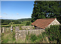
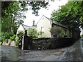
Old Pigsty, Manor Farm
Beside a public footpath behind the farm house.
Image: © Des Blenkinsopp
Taken: 23 Aug 2014
0.11 miles
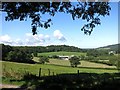
3
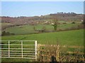
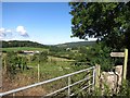
Upper Milton
Just a view showing the typical woodland and grazing in this area on the upper slopes of the Mendips. Not much else to find.
Image: © Graham Richards
Taken: 23 Dec 2005
0.12 miles
4
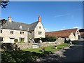
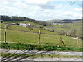
Looking south-southwest from Tynings Lane
Towards Model Farm, where I stayed in the farm’s self-catering cottage, a converted pig shed, called Garden Cottage from 1-8 April 2016. I wrote in the guest book “a lovely discovery of comfort and peace” http://www.modelfarmcottages.co.uk/
Image: © John Baker
Taken: 2 Apr 2016
0.15 miles
7
Looking west from Old Bristol Road
Towards Model Farm, where I stayed in the farm’s self-catering cottage, a converted pig shed, called Garden Cottage from 1-8 April 2016. I wrote in the guest book “a lovely discovery of comfort and peace” http://www.modelfarmcottages.co.uk/
Image: © John Baker
Taken: 2 Apr 2016
0.22 miles
8
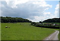
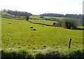
Footpath to Model Farm
A footpath runs through Model farm, following the tarmac road, and eventually drops down into Wells further to the south.
Image: © Sharon Loxton
Taken: 3 Jul 2009
0.23 miles

10
Towards Model Farm
View from Old Bristol Road.
Image: © Des Blenkinsopp
Taken: 23 Aug 2014
0.25 miles