IMAGES TAKEN NEAR TO
Milton, WELLS, BA5 3AE
Introduction
This page details the photographs taken nearby to BA5 3AE by members of the Geograph project.
The Geograph project started in 2005 with the aim of publishing, organising and preserving representative images for every square kilometre of Great Britain, Ireland and the Isle of Man.

There are currently over 7.5m images from over14,400 individuals and you can help contribute to the project by visiting https://www.geograph.org.uk
Image Map
Images are licensed for reuse under creativecommons.org/licenses/by-sa/2.0
Notes
- Clicking on the map will re-center to the selected point.
- The higher the marker number, the further away the image location is from the centre of the postcode.
Image Listing (31 Images Found)
Images are licensed for reuse under creativecommons.org/licenses/by-sa/2.0
Image
Details
Distance
1
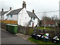
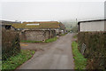
Garden Cottage, Model Farm
The white-painted house is where the owners of the farm live, while the single storey building is Garden Cottage. It was converted from a pig shed and was where I stayed from 1-8 April 2016. I wrote in the guest book “a lovely discovery of comfort and peace” http://www.modelfarmcottages.co.uk/
Image: © John Baker
Taken: 6 Apr 2016
0.00 miles
2
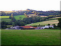
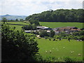
Model farm
The farm nestles south of the Mendip Hills just to the north of Wells. The wooded area top right is Rookham, through which the Old Bristol road (Wells - Bristol) runs.
Image: © Sharon Loxton
Taken: 29 Aug 2007
0.02 miles
3
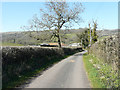
Model Farm
On the Monarch's Way, north of Wells
Image: © Tim Heaton
Taken: 10 Feb 2015
0.03 miles
4
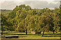
Apple Trees in an Orchard, near Wells, Somerset
At model farm, between Wells and Wookey Hole.
Image: © Andrew Tryon
Taken: 4 Oct 2022
0.06 miles
5
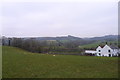
Model Farm
The lane peters out here. There are cows just unable to see over the wall.
Image: © Bill Boaden
Taken: 30 Dec 2016
0.07 miles
6
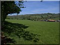
Model Farm
From Tynings Lane looking south across farmland. On the right side of the photograph is Milton Hill and in the distance on the left is Glastonbury Tor.
Image: © Sharon Loxton
Taken: 3 Jul 2009
0.07 miles
7
The lane approaching Model Farm
Although non-authorized vehicles are banned from using this lane, pedestrians may as it forms access to a footpath beyond the farm. I stayed in the farm’s self-catering cottage, a converted pig shed, called Garden Cottage from 1-8 April 2016. I wrote in the guest book “a lovely discovery of comfort and peace” http://www.modelfarmcottages.co.uk/
Image: © John Baker
Taken: 2 Apr 2016
0.07 miles
8
Field by Model Farm
Between Round Wood, on the slopes of Milton Hill on the left, and Model Farm, on the right.
Image: © Derek Harper
Taken: 22 May 2010
0.10 miles
9
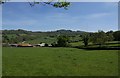
Model Farm
The left part of the image is almost identical to the view in Image, taken a few metres to the south. Up on the right, on Pen Hill, is Image
Image: © Derek Harper
Taken: 22 May 2010
0.11 miles
