IMAGES TAKEN NEAR TO
Upper Godney, WELLS, BA5 1RY
Introduction
This page details the photographs taken nearby to BA5 1RY by members of the Geograph project.
The Geograph project started in 2005 with the aim of publishing, organising and preserving representative images for every square kilometre of Great Britain, Ireland and the Isle of Man.

There are currently over 7.5m images from over14,400 individuals and you can help contribute to the project by visiting https://www.geograph.org.uk
Image Map
Images are licensed for reuse under creativecommons.org/licenses/by-sa/2.0
Notes
- Clicking on the map will re-center to the selected point.
- The higher the marker number, the further away the image location is from the centre of the postcode.
Image Listing (11 Images Found)
Images are licensed for reuse under creativecommons.org/licenses/by-sa/2.0
Image
Details
Distance
2
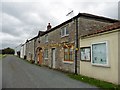
Former school, Upper Godney
Some polychrome brickwork makes these Vicrotian buildings distinctive.
Image: © Derek Harper
Taken: 15 Aug 2011
0.05 miles
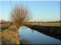
4
River Sheppey
The river runs alongside the minor road from Polsham to Godney . This is just west of Garslade farm with the usual willow trees leaning across the river banks.
Image: © Nigel Mykura
Taken: 6 Feb 2011
0.13 miles
5
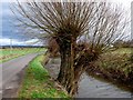
Pollarded willow
The willows are still pollarded regularly though not so much use is made of the resulting twigs these days. These trees are next to the River Sheppey just west of Garslade Farm next to the road from Polsham to Godney.
Image: © Nigel Mykura
Taken: 6 Feb 2011
0.17 miles
6
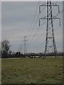
Pylons and Cows
Pylons marching their way across the levels. I once saw a military helicopter fly underneath the cables just here! There were no cows around then though.
Image: © Graham Richards
Taken: 18 Dec 2005
0.18 miles
7
Pollarded willow by the River Sheppey at Godney
These trees are an essential part of the landscape of the Levels and Moors: quick-growing, formerly much used for basket-making, and now cut back every five years or so under landscape stewardship schemes
Image: © Edwin Graham
Taken: 9 Jan 2011
0.19 miles
9
Pill Box in Godney
I've come across several of these on the levels. Heaven knows what they were defending!
Image: © Graham Richards
Taken: 18 Dec 2005
0.20 miles
10
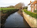
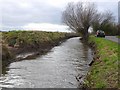
River Sheppey in Upper Godney - facing west
The River Sheppey is a tributary of the river Brue. It originates in the Mendips; the source being a group of springs to the west of the settlement of Doulting where water draining through the limestone of the Mendips appears. From Doulting the Sheppey flows southwest through the wetlands to the north of the Polden Hills. At Charlton parts of the rivers course have been culverted and the river flows beneath ground through Shepton Mallet.
The river reappears at Darshill and its course continues southwest through Croscombe, Dinder, Woodford, Coxley. From Coxley the course of the river heads north through Hay Moor and North Moor, wetlands, supplied and drained by the river. The river continues west through Ash Moor, here the river course turns sharply to the south through Frogmore and west through Godney. At Lower Godney the river is channelled through the ‘James Wear River’ and the ‘Decoy Rhine’to Westhay Level where it joins ‘Whites River’ and then the River Brue. No part of the Sheppey is tidal.
Image: © Sharon Loxton
Taken: 2 Feb 2008
0.22 miles