IMAGES TAKEN NEAR TO
Coxley, WELLS, BA5 1RQ
Introduction
This page details the photographs taken nearby to BA5 1RQ by members of the Geograph project.
The Geograph project started in 2005 with the aim of publishing, organising and preserving representative images for every square kilometre of Great Britain, Ireland and the Isle of Man.

There are currently over 7.5m images from over14,400 individuals and you can help contribute to the project by visiting https://www.geograph.org.uk
Image Map (Loading...)


Getting Data...Please wait
Leaflet Map data © OpenStreetMap
Images are licensed for reuse under creativecommons.org/licenses/by-sa/2.0
Notes
- Clicking on the map will re-center to the selected point.
- The higher the marker number, the further away the image location is from the centre of the postcode.
Image Listing (13 Images Found)
Images are licensed for reuse under creativecommons.org/licenses/by-sa/2.0
Image
Details
Distance

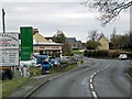
3
'Sense' hair and beauty salon, Coxley
Image: © Roger Cornfoot
Taken: 14 Mar 2018
0.03 miles
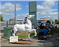
4
Here be giants ...!
At the western end of Coxley, the bull, statue of "The Thinker" and the horse advertise an architectural reclamation yard to the north of the filling station
Image: © David Smith
Taken: 28 Sep 2011
0.05 miles
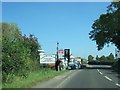
5
Entrance to the Wells Reclamation Company, Coxley, Wells
This is on Wells Road (A39).
Image: © habiloid
Taken: 10 Aug 2013
0.05 miles
7
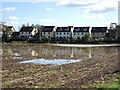
Wet field for neighbours
New housing along the A39 through Coxley and the backs of which have a rather soggy field for company.
Image: © Neil Owen
Taken: 21 Oct 2021
0.09 miles
8
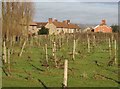
Coxley Vineyard
The Somerset Levels are clearly well suited for grapes, not that I like English wine that much. The Mendips can be seen in the background, in particular the Mendip Mast at Image
Image: © Graham Richards
Taken: 24 Dec 2005
0.11 miles
9
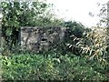
Coxley pillbox
As part of the general installation of defensive positions in southern England many pillboxes were built. This one is part of Stop Line Green and runs through this part of Somerset. It is just north of Coxley and defended what used to be the Somerset and Dorset Joint Railway (Wells Branch) line that ran close by the River Sheppey - a railway now lost.
Image: © Neil Owen
Taken: 21 Oct 2021
0.11 miles
10
Saffora Bridge
The River Sheppey is crossed here near a pillbox, by a footbridge with a name on it. There appears to be no information why it is so named, sadly.
Image: © Neil Owen
Taken: 21 Oct 2021
0.11 miles