IMAGES TAKEN NEAR TO
Stoppers Lane, WELLS, BA5 1QR
Introduction
This page details the photographs taken nearby to Stoppers Lane, BA5 1QR by members of the Geograph project.
The Geograph project started in 2005 with the aim of publishing, organising and preserving representative images for every square kilometre of Great Britain, Ireland and the Isle of Man.

There are currently over 7.5m images from over14,400 individuals and you can help contribute to the project by visiting https://www.geograph.org.uk
Image Map (Loading...)


Getting Data...Please wait
Leaflet Map data © OpenStreetMap
Images are licensed for reuse under creativecommons.org/licenses/by-sa/2.0
Notes
- Clicking on the map will re-center to the selected point.
- The higher the marker number, the further away the image location is from the centre of the postcode.
Image Listing (21 Images Found)
Images are licensed for reuse under creativecommons.org/licenses/by-sa/2.0
Image
Details
Distance
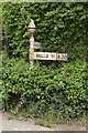
2

Old Direction Sign - Signpost by the A39, Glastonbury Road, St Cuthburt Out
Pyramid finial - 1 arm; Somerset SCC pyramid by the A39, in parish of St. Cuthbert Out parish (Mendip District), Upper Coxley, junction of Main Road and Stoppers Lane, on grass verge by hedge.
Surveyed
Milestone Society National ID: SO_ST5343A
Image: © Milestone Society
Taken: Unknown
0.09 miles

5
Littlewell Spring
On the side of the main road at Littlewell in the village of Coxley
Image: © Allan Cole
Taken: 19 Mar 2009
0.15 miles
6
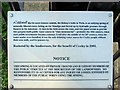
Littlewell Plaque
Information plaque for the well at Littlewell on the main road between Wells and Glastonbury just in side the village of Coxley
Image: © Allan Cole
Taken: 19 Mar 2009
0.15 miles
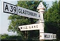
7
Old Direction Sign - Signpost by the A39, Glastonbury Road, Coxley
Pyramid finial - 2 arms; Somerset SCC pyramid - fingered arms by the A39, in parish of St Cuthbert Out (Mendip District), Coxley, junction of Glastonbury Road with Mill Lane, in the hedge.
Surveyed
Milestone Society National ID: SO_ST5343.
Image: © Milestone Society
Taken: Unknown
0.19 miles
8
Direction Sign ? Signpost on the A39 at Coxley
Located at Coxley, on the southwest side of the junction of the A39 Glastonbury Road and Mill Lane in St Cuthbert Out parish. 3 arms and pyramid finial. An older photo of https://www.geograph.org.uk/photo/6038152 when it had three arms.
Milestone Society National ID: SO_ST5343
Image: © W Marsh
Taken: Unknown
0.19 miles
9

Direction Sign ? Signpost on the A39 at Coxley
Located at Coxley, on the southwest side of the junction of the A39 Glastonbury Road and Mill Lane in St Cuthbert Out parish. 3 arms and pyramid finial. See https://www.geograph.org.uk/photo/6577430 for a 1987 photo with three arms and https://www.geograph.org.uk/photo/6038152b for a 2017 photo when one arm was missing
Milestone Society National ID: SO_ST5343
Image: © R Raynsford
Taken: Unknown
0.19 miles
10
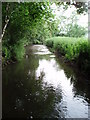
The River Sheppey
The River Sheppey flowing westwards towards the Somerset Levels from just to the west of Woodford Bridge.
Image: © Sharon Loxton
Taken: 18 Jun 2006
0.19 miles