IMAGES TAKEN NEAR TO
Keward, WELLS, BA5 1QF
Introduction
This page details the photographs taken nearby to Keward, BA5 1QF by members of the Geograph project.
The Geograph project started in 2005 with the aim of publishing, organising and preserving representative images for every square kilometre of Great Britain, Ireland and the Isle of Man.

There are currently over 7.5m images from over14,400 individuals and you can help contribute to the project by visiting https://www.geograph.org.uk
Image Map
Images are licensed for reuse under creativecommons.org/licenses/by-sa/2.0
Notes
- Clicking on the map will re-center to the selected point.
- The higher the marker number, the further away the image location is from the centre of the postcode.
Image Listing (14 Images Found)
Images are licensed for reuse under creativecommons.org/licenses/by-sa/2.0
Image
Details
Distance

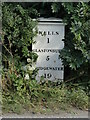
2
Keward, milepost
Cast-iron milepost on Glastonbury Road (A39), of a type made by Carson & Miller of Warminster. Legend reads "WELLS/1/GLASTONBURY/5/BRIDGEWATER/19".
Image: © Mike Faherty
Taken: 12 Apr 2009
0.08 miles
3
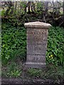
Old Milepost by the A39, Glastonbury Road, Keward, Wells
Cast iron post by the A39, in parish of ST CUTHBERT OUT (MENDIP District), a mile South West of Wells, on grass verge beside road, on South side of road. C&M Classical iron casting, erected by the Wells turnpike trust in the 19th century.
Inscription reads:- : WELLS / 1 / GLASTONBURY / 5 / BRIDGEWATER / 19 :
Milestone Society National ID: SO_BWWL19
Image: © Mike Faherty
Taken: 12 Apr 2009
0.08 miles
4
Old Milepost by the A39, Glastonbury Road, Keward, Wells
Cast iron post by the A39, in parish of ST CUTHBERT OUT (MENDIP District), a mile South West of Wells, on grass verge beside road, on South side of road. C&M Classical iron casting, erected by the Wells turnpike trust in the 19th century.
Inscription reads:- : WELLS / 1 / GLASTONBURY / 5 / BRIDGEWATER / 19 :
Milestone Society National ID: SO_BWWL19
Image: © Roadside Relics
Taken: 29 Jul 2024
0.08 miles
5

Ruined barn by the A39
Half the roof has gone from this small barn by the hedge east of Sugar Loaf.
Image: © Derek Harper
Taken: 8 Mar 2010
0.08 miles
6
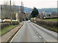
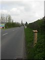
Glastonbury Road (A39) approaching Wells
Image: © David Dixon
Taken: 10 Dec 2013
0.11 miles
7

Direction Sign - Signpost on the A39 Glastonbury Road between Coxley and Keward
Pyramid finial - 3 arms; Somerset SCC pyramid by the A39, in parish of St Cuthbert Out (Mendip District), between Coxley and Keward on the northwest side of the T junction of the A39 Glastonbury Road and Woodford Lane.
surveyed
Milestone Society National ID: SO_ST5344
Image: © A Riley
Taken: Unknown
0.12 miles
8

Direction Sign ? Signpost on the A39 at Coxley
Located between Coxley and Keward on the northwest side of the T junction of the A39 Glastonbury Road and Woodford Lane in St Cuthbert Out parish. 3 arms and pyramid finial. Restored since the 2017 photo, see https://www.geograph.org.uk/photo/6072961.
Milestone Society National ID: SO_ST5344
Image: © J Dowding
Taken: 12 Apr 2021
0.12 miles
9
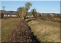
Former railway line near Wells
The dismantled Somerset Central Railway, running parallel to the Keward Brook. Wells is in the background.
Image: © Derek Harper
Taken: 8 Mar 2010
0.15 miles
10
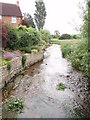
Keward Brook
The brook is flowing towards the photographer past a new housing estate on the left. Approximately a mile further west the brook joins the River Sheppey and heads off towards the Somerset Levels.
Image: © Sharon Loxton
Taken: 18 Jun 2006
0.15 miles