IMAGES TAKEN NEAR TO
Bleadney, WELLS, BA5 1PF
Introduction
This page details the photographs taken nearby to BA5 1PF by members of the Geograph project.
The Geograph project started in 2005 with the aim of publishing, organising and preserving representative images for every square kilometre of Great Britain, Ireland and the Isle of Man.

There are currently over 7.5m images from over14,400 individuals and you can help contribute to the project by visiting https://www.geograph.org.uk
Image Map (Loading...)


Getting Data...Please wait
Leaflet Map data © OpenStreetMap
Images are licensed for reuse under creativecommons.org/licenses/by-sa/2.0
Notes
- Clicking on the map will re-center to the selected point.
- The higher the marker number, the further away the image location is from the centre of the postcode.
Image Listing (6 Images Found)
Images are licensed for reuse under creativecommons.org/licenses/by-sa/2.0
Image
Details
Distance
2
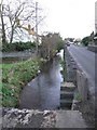
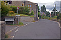
Stream and Road in Henton
Photo taken looking east. The stream follows the road for several miles starting at Burcott Mill Imagewhere it is the run off from the mill pond. Its course is canal like following the contour of the hill some 30ft above the levels. Along its length there are sluices that in times of high rain allow the excess to run down to the levels.
Image: © Graham Richards
Taken: 17 Dec 2005
0.14 miles
4
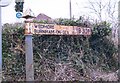
Direction Sign - Signpost by the B3139, west of Bleadney
Pyramid finial - 1 arm; Somerset SCC pyramid by the B3139, in parish of Wookey (Mendip District), Bleadney village, West end.
Surveyed
Milestone Society National ID: SO_ST4845
Image: © Milestone Society
Taken: Unknown
0.17 miles