IMAGES TAKEN NEAR TO
Mabel Way, WELLS, BA5 1FS
Introduction
This page details the photographs taken nearby to Mabel Way, BA5 1FS by members of the Geograph project.
The Geograph project started in 2005 with the aim of publishing, organising and preserving representative images for every square kilometre of Great Britain, Ireland and the Isle of Man.

There are currently over 7.5m images from over14,400 individuals and you can help contribute to the project by visiting https://www.geograph.org.uk
Image Map (Loading...)


Getting Data...Please wait
Leaflet Map data © OpenStreetMap
Images are licensed for reuse under creativecommons.org/licenses/by-sa/2.0
Notes
- Clicking on the map will re-center to the selected point.
- The higher the marker number, the further away the image location is from the centre of the postcode.
Image Listing (20 Images Found)
Images are licensed for reuse under creativecommons.org/licenses/by-sa/2.0
Image
Details
Distance
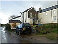

4

New farm buildings, Manor Farm
These new farm buildings at Upper Coxley lie across the mapped line of a footpath, causing some confusion.
Image: © Derek Harper
Taken: 8 Mar 2010
0.13 miles
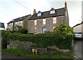
5
Houses in Upper Coxley
View of houses in Upper Coxley
Image: © Malcolm Spicer
Taken: 20 Jul 2006
0.15 miles
6
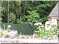
Peacock in garden
The garden of a house in Harter's Hill Lane.
Image: © Malcolm Spicer
Taken: 20 Jul 2006
0.15 miles
7

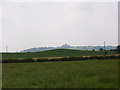
View north from Harter's Hill Farm
Cows in pasture in the foreground; in the distance Hay Hill can be seen.
Image: © Malcolm Spicer
Taken: 20 Jul 2006
0.15 miles
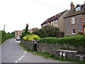
8

North of Harter's Hill Lane
The land rises to Upper Coxley
Image: © Malcolm Spicer
Taken: 20 Jul 2006
0.15 miles
9
Pill Moor
Southwest over Pill Moor; in the middle ground is Harter's hill and in the distance is Glastonbury Tor.
Image: © Malcolm Spicer
Taken: 20 Jul 2006
0.15 miles
10
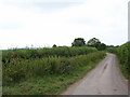
Pillmoor Drove
Pillmoor Drove looking southwest
Image: © Malcolm Spicer
Taken: 20 Jul 2006
0.15 miles