IMAGES TAKEN NEAR TO
Hales Close, WELLS, BA5 1DQ
Introduction
This page details the photographs taken nearby to Hales Close, BA5 1DQ by members of the Geograph project.
The Geograph project started in 2005 with the aim of publishing, organising and preserving representative images for every square kilometre of Great Britain, Ireland and the Isle of Man.

There are currently over 7.5m images from over14,400 individuals and you can help contribute to the project by visiting https://www.geograph.org.uk
Image Map
Images are licensed for reuse under creativecommons.org/licenses/by-sa/2.0
Notes
- Clicking on the map will re-center to the selected point.
- The higher the marker number, the further away the image location is from the centre of the postcode.
Image Listing (5 Images Found)
Images are licensed for reuse under creativecommons.org/licenses/by-sa/2.0
Image
Details
Distance
1

Field by Monks Ford
Fields south-west of Wookey. Beyond is Preywater Bridge.
Image: © Neil Owen
Taken: 21 Oct 2021
0.03 miles
2
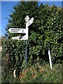
Signpost on Knowle Lane
Nicely spruced up it is, too.
Image: © Neil Owen
Taken: 21 Oct 2021
0.15 miles
3
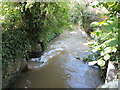
The Axe at Preywater
The river issues from the lower slopes of the Mendips near Wookey Hole, flowing through Wookey village.
Image: © Neil Owen
Taken: 21 Oct 2021
0.16 miles
4
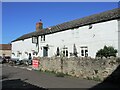
The Ring O' Bells, Wookey
The inn dates back to the fourteenth century.
Image: © Neil Owen
Taken: 21 Oct 2021
0.17 miles
5
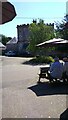
Mellifont Abbey
This is now a care home, I think. I must say it looks rather grand
Image: © Ant Basterfield
Taken: 22 Jun 2022
0.22 miles