IMAGES TAKEN NEAR TO
Hurst Batch, WELLS, BA5 1BE
Introduction
This page details the photographs taken nearby to Hurst Batch, BA5 1BE by members of the Geograph project.
The Geograph project started in 2005 with the aim of publishing, organising and preserving representative images for every square kilometre of Great Britain, Ireland and the Isle of Man.

There are currently over 7.5m images from over14,400 individuals and you can help contribute to the project by visiting https://www.geograph.org.uk
Image Map
Images are licensed for reuse under creativecommons.org/licenses/by-sa/2.0
Notes
- Clicking on the map will re-center to the selected point.
- The higher the marker number, the further away the image location is from the centre of the postcode.
Image Listing (12 Images Found)
Images are licensed for reuse under creativecommons.org/licenses/by-sa/2.0
Image
Details
Distance
1
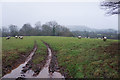
Field of sheep near Marley Grange
The ground is quite damp at this time of year. The sheep appear to be Suffolks.
Image: © Bill Boaden
Taken: 30 Dec 2016
0.10 miles
2
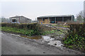
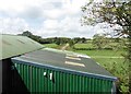
Farm buildings near Marley Grange
As viewed from Titlands Lane, where everything is currently looking a bit wet.
Image: © Bill Boaden
Taken: 30 Dec 2016
0.10 miles
3
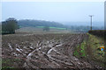
Muddy field near Marley Grange
Some ploughing is taking place down the slope to the right, though I would not have thought conditions are ideal. The view is towards Wookey Hole and the Mendips behind are shrouded in mist.
Image: © Bill Boaden
Taken: 30 Dec 2016
0.11 miles
4
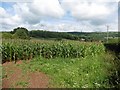
Field of maize, next to Titlands Lane
Image: © Roger Cornfoot
Taken: 17 Aug 2020
0.12 miles
5
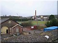
St Cuthberts Paper Mill
St Cuthberts Paper Mill is in the distance where the chimney is. You can see demonstrations of paper making if you visit the Wookey Hole cave complex (where Wookey paper mill is). The building in the foreground is an old station on the now disused railway line that ran from Wells to Cheddar.
Image: © Graham Richards
Taken: 2 Jan 2006
0.13 miles
6
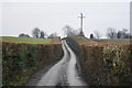
Jogging up the lane
The hedgerows on each side are very broad and can only be cut mechanically.
Image: © Bill Boaden
Taken: 30 Dec 2016
0.14 miles
7
Old Railway
The track of an old railway running NW out of Wells can be seen. The line was a victim of Beeching. The shed in the foreground (built over the line) is used by one of the Carnival Clubs for building their elaborate floats.
Image: © Graham Richards
Taken: 2 Jan 2006
0.16 miles
8
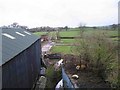
Farm building on the old 'Strawberry Line'
The abandoned trackbed can be seen in the distance.
Image: © Roger Cornfoot
Taken: 17 Aug 2020
0.17 miles
9
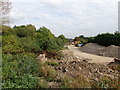
View of the old railway trackbed looking toward Haybridge
On Titlands lane old bridge looking at the site of the former route of the Yatton to Witham Railway Now it seems this part is used for storage of stone and railway sleepers these can't still be the ones taken up from the track in the mid 1960's can they?
Image: © Ant Basterfield
Taken: 2 Oct 2014
0.18 miles
10

View of Trackbed of the old Yatton to Witham railway
Here taken from the bridge on Titlands lane is the view of the Cheddar valley branch line looking toward Westbury Sub Mendip
Image: © Ant Basterfield
Taken: 2 Oct 2014
0.19 miles