IMAGES TAKEN NEAR TO
BA4 6ZN
Introduction
This page details the photographs taken nearby to BA4 6ZN by members of the Geograph project.
The Geograph project started in 2005 with the aim of publishing, organising and preserving representative images for every square kilometre of Great Britain, Ireland and the Isle of Man.

There are currently over 7.5m images from over14,400 individuals and you can help contribute to the project by visiting https://www.geograph.org.uk
Image Map
Images are licensed for reuse under creativecommons.org/licenses/by-sa/2.0
Notes
- Clicking on the map will re-center to the selected point.
- The higher the marker number, the further away the image location is from the centre of the postcode.
Image Listing (274 Images Found)
Images are licensed for reuse under creativecommons.org/licenses/by-sa/2.0
Image
Details
Distance
2
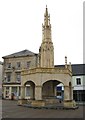
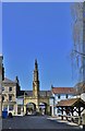
Market cross, Shepton Mallet
The market cross or butter cross was built by Walter Buckland around the year 1500 and was generally used by farmers who sold their butter, eggs, milk and poultry under its stone gallery.
Image: © Maigheach-gheal
Taken: 7 Mar 2012
0.01 miles
3
Any distance you like, Shepton Mallet
The identical plaques are attached to the Market Cross seen in Image
Image: © Maigheach-gheal
Taken: 7 Mar 2012
0.01 miles
4
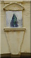
Sundial on the Market Cross
The sundial is attached to Shepton Mallets market cross Image
Sundials or sun clocks are considered to be the oldest known device for the measurement of time and one of the most ancient scientific instruments.
The oldest known true sundial was built around 1500BC in Egypt. Shaped like a letter 'L' the length of the shadow cast by the vertical leg along the horizontal leg indicated the time. The Romans perfected the horizontal sundial we know today and invented portable travelling versions.
Image: © Maigheach-gheal
Taken: 7 Mar 2012
0.01 miles
5
Regulations for the Market Cross
The board displaying the regulations concerning the use of the Market Cross. For a view of the Market Cross Image
Image: © Maigheach-gheal
Taken: 7 Mar 2012
0.01 miles
6
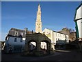
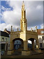
Shepton Mallet: the market cross
Originating in 1520 but rebuilt in 1841, the cross stands at the end of Image, along which we look with only a glimpse of the 1970s complex at the eastern end.
Image: © Chris Downer
Taken: 18 Feb 2013
0.01 miles
7
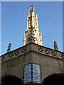
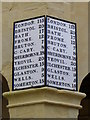
Shepton Mallet: mileages on the market cross
A table of road distances is affixed twice to Image The moon can be seen at the bottom of the sunlit segment of the cross.
Image: © Chris Downer
Taken: 18 Feb 2013
0.01 miles
8
Shepton Mallet Market Cross
A fine monument in rather a small market place.
The town name is from Old English "sceap tun" = sheep farm, and from Robert Malet who was the boss here at some stage.
Image: © Des Blenkinsopp
Taken: 27 Aug 2014
0.01 miles
10
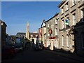
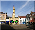
Shepton Mallet: bottom of the High Street
The High Street widens out as it reaches the marketplace, with Image conspicuous ahead of us.
Image: © Chris Downer
Taken: 18 Feb 2013
0.01 miles