IMAGES TAKEN NEAR TO
Hembridge, SHEPTON MALLET, BA4 6TZ
Introduction
This page details the photographs taken nearby to Hembridge, BA4 6TZ by members of the Geograph project.
The Geograph project started in 2005 with the aim of publishing, organising and preserving representative images for every square kilometre of Great Britain, Ireland and the Isle of Man.

There are currently over 7.5m images from over14,400 individuals and you can help contribute to the project by visiting https://www.geograph.org.uk
Image Map
Images are licensed for reuse under creativecommons.org/licenses/by-sa/2.0
Notes
- Clicking on the map will re-center to the selected point.
- The higher the marker number, the further away the image location is from the centre of the postcode.
Image Listing (7 Images Found)
Images are licensed for reuse under creativecommons.org/licenses/by-sa/2.0
Image
Details
Distance
2
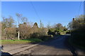
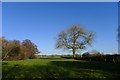
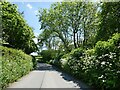
The Monarch's Way crossing the road at Hembridge
Image: © Tim Heaton
Taken: 9 Feb 2015
0.00 miles
4
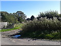
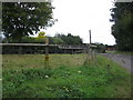
A Tardis at Mill Farm
Rather incongruously nestling next to a ruined 'mediaeval' chapel.
Image: © HelenK
Taken: 26 Sep 2007
0.04 miles
6
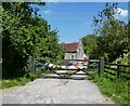
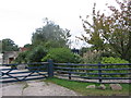
Yew Tree Farm
This seems to be named Mill Farm on the map, but the wooden sign proclaims it to be Yew Tree Farm.
Image: © HelenK
Taken: 26 Sep 2007
0.05 miles