IMAGES TAKEN NEAR TO
Cockmill Lane, SHEPTON MALLET, BA4 6TR
Introduction
This page details the photographs taken nearby to Cockmill Lane, BA4 6TR by members of the Geograph project.
The Geograph project started in 2005 with the aim of publishing, organising and preserving representative images for every square kilometre of Great Britain, Ireland and the Isle of Man.

There are currently over 7.5m images from over14,400 individuals and you can help contribute to the project by visiting https://www.geograph.org.uk
Image Map
Images are licensed for reuse under creativecommons.org/licenses/by-sa/2.0
Notes
- Clicking on the map will re-center to the selected point.
- The higher the marker number, the further away the image location is from the centre of the postcode.
Image Listing (11 Images Found)
Images are licensed for reuse under creativecommons.org/licenses/by-sa/2.0
Image
Details
Distance
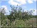
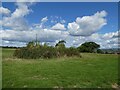
2
Field on Kings Hill
With a glimpse of a view across the Whitelake valley past the trees.
Image: © Derek Harper
Taken: 22 Jul 2012
0.11 miles
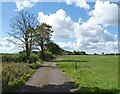
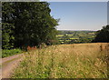
3
Trough and field, Kings Hill
The track leads down into the festival site. The view is towards Worthy Farm, which is visible just left of the tree.
Image: © Derek Harper
Taken: 22 Jul 2012
0.13 miles
5
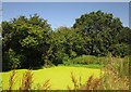
Green pond, Kings Hill
A weed-covered pond by the track seen in Image, its yellow-green surface contrasting with the red sorrel in the foreground.
Image: © Derek Harper
Taken: 22 Jul 2012
0.15 miles
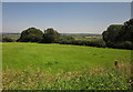
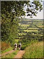
7
On Kings Hill
From a meadow beside the track shown in Image, with a view across the Glastonbury Festival site.
Image: © Derek Harper
Taken: 22 Jul 2012
0.18 miles
8
Covered reservoir at Pennard Hill Farm
Beneath the shrubbery!
Image: © Roger Cornfoot
Taken: 16 Sep 2022
0.18 miles
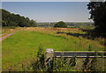
9
Track down Kings Hill
Leading into the Glastonbury Festival site, the eastern side of which can be seen ahead.
Image: © Derek Harper
Taken: 22 Jul 2012
0.19 miles