IMAGES TAKEN NEAR TO
The Old Threshing Mill, SHEPTON MALLET, BA4 6SP
Introduction
This page details the photographs taken nearby to The Old Threshing Mill, BA4 6SP by members of the Geograph project.
The Geograph project started in 2005 with the aim of publishing, organising and preserving representative images for every square kilometre of Great Britain, Ireland and the Isle of Man.

There are currently over 7.5m images from over14,400 individuals and you can help contribute to the project by visiting https://www.geograph.org.uk
Image Map
Images are licensed for reuse under creativecommons.org/licenses/by-sa/2.0
Notes
- Clicking on the map will re-center to the selected point.
- The higher the marker number, the further away the image location is from the centre of the postcode.
Image Listing (8 Images Found)
Images are licensed for reuse under creativecommons.org/licenses/by-sa/2.0
Image
Details
Distance
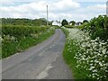
1
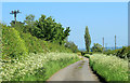
2012 : Looking east along Hedge Lane
About to pass Hedge Farm on the left.
Image: © Maurice Pullin
Taken: 22 May 2012
0.07 miles
3
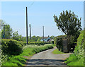
2012 : West along Hedge Lane
The end is in sight - almost, this side of the house at Lower Hedge.
About to pass the entrance to Hedge Farm.
Image: © Maurice Pullin
Taken: 22 May 2012
0.09 miles
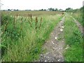
4
Gateway to a public footpath
A path leads south from Hedge Farm through, in 2007, fields of broad beans.
Image: © Neville Goodman
Taken: 4 Aug 2007
0.09 miles
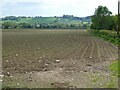
5
A poor crop?
A field of broad beans (not looking too healthy) with the buildings of Hedge Farm at the end of the track.
Image: © Neville Goodman
Taken: 4 Aug 2007
0.15 miles
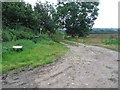
8
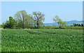
2012 : West from the end of Hedge Lane
Hedge Lane ends here but this is where it would go if it went further.
The hill in the distance is one of the Mendips, so minor it does not rate a name on OS Explorer 142.
Image: © Maurice Pullin
Taken: 22 May 2012
0.25 miles