IMAGES TAKEN NEAR TO
High Street, SHEPTON MALLET, BA4 6NT
Introduction
This page details the photographs taken nearby to High Street, BA4 6NT by members of the Geograph project.
The Geograph project started in 2005 with the aim of publishing, organising and preserving representative images for every square kilometre of Great Britain, Ireland and the Isle of Man.

There are currently over 7.5m images from over14,400 individuals and you can help contribute to the project by visiting https://www.geograph.org.uk
Image Map
Images are licensed for reuse under creativecommons.org/licenses/by-sa/2.0
Notes
- Clicking on the map will re-center to the selected point.
- The higher the marker number, the further away the image location is from the centre of the postcode.
Image Listing (2 Images Found)
Images are licensed for reuse under creativecommons.org/licenses/by-sa/2.0
Image
Details
Distance
1

Milton Clevedon: postbox № BA4 74
Described as "Upper Milton" on the Royal Mail's list of boxes – there is indeed quite a steep hill down to Manor Farm and the church further north along the B3081.
This Victorian postbox, like the similar one down the hill (Image) is emptied at 11:30am on weekdays and at 9am on Saturdays.
Image: © Chris Downer
Taken: 23 May 2009
0.02 miles
2
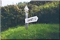
Direction Sign - Signpost on the B3081 in Milton Clevedon parish
Pyramid finial - 1 arm; Somerset SCC pyramid by the B3081, in parish of Milton Clevedon (Mendip District), on the south side of the T junction of the B3081 High Street and lane to Lamyatt.
surveyed
Milestone Society National ID: SO_ST6637
Image: © Milestone Society
Taken: Unknown
0.04 miles