IMAGES TAKEN NEAR TO
Batcombe, SHEPTON MALLET, BA4 6HE
Introduction
This page details the photographs taken nearby to BA4 6HE by members of the Geograph project.
The Geograph project started in 2005 with the aim of publishing, organising and preserving representative images for every square kilometre of Great Britain, Ireland and the Isle of Man.

There are currently over 7.5m images from over14,400 individuals and you can help contribute to the project by visiting https://www.geograph.org.uk
Image Map
Images are licensed for reuse under creativecommons.org/licenses/by-sa/2.0
Notes
- Clicking on the map will re-center to the selected point.
- The higher the marker number, the further away the image location is from the centre of the postcode.
Image Listing (55 Images Found)
Images are licensed for reuse under creativecommons.org/licenses/by-sa/2.0
Image
Details
Distance
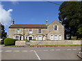
1
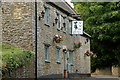
The Three Horseshoes, Batcombe
Gastro pub in 17th century coaching inn.
Image: © Rob Noble
Taken: 19 Jul 2008
0.01 miles
2
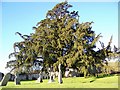
Yew Tree, St Mary's Church, Batcombe
The ancient tradition that this evergreen sheltered the first Christian missionaries to Britain before their churches were built is one of the many explanations put forward to account for the large numbers of yews found in country churchyards. The yew is also a life symbol, and was sometimes scattered on graves. The longbows of medieval archers came from straight, knot-free lengths cut from tall, selected trees. But these were unlikely to be churchyard yews – the best bow staves were imported from Spain.
Image: © Maigheach-gheal
Taken: 1 Jan 2010
0.02 miles
3
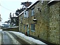
Winter at the Three Horseshoes, Batcombe
View south down through the village past the local pub with the whole village and countryside covered in snow.
Image: © Nigel Mykura
Taken: 6 Feb 2009
0.02 miles
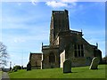
4
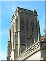
St Mary's church tower and clock, Batcombe
The church is quite an ornate one for such a small village. The clock seems to keep good time.
Image: © Brian Robert Marshall
Taken: 19 Mar 2008
0.02 miles
5
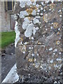
Benchmarks on St Mary's church, Batcombe
An unusual find - is this a pair of cutmarks on the church? The lower one seems crisper and therefore the newer; the upper one, partly being affected by lichens, appears to have a softer outline.
See https://www.bench-marks.org.uk/bm109243 for the entry in the Benchmark Database, or Image] for a wider view.
Image: © Neil Owen
Taken: 8 Jul 2019
0.02 miles
6
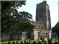
St Mary in the evening sunlight
A view of the north side, showing the striking square tower. Although it's thought there was a Saxon era church of some description on this site, the oldest parts of the current structure is believed to date from around the thirteenth century. A lot of it was built in the fifteenth and sixteenth, including the tower in around 1540 - one of the last of the great East Somerset Towers.
Image: © Neil Owen
Taken: 8 Jul 2019
0.03 miles
7
The Old Rectory, Batcombe, Somerset
A grade II listed building.
Image: © Robin Webster
Taken: 2 Apr 2017
0.03 miles
8

St Mary's Church Batcombe
Picture shows St Mary's church and on the right hand side the old vicarage.
Image: © Ray Beer
Taken: 15 Feb 2005
0.03 miles
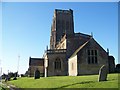
9
St Mary's church, Batcombe
The church building is all, just, in this square.
Image: © Brian Robert Marshall
Taken: 19 Mar 2008
0.03 miles
10
St Mary's Church, Batcombe
The church has its origins in the 15th century and it was restored in the 19th century. Built of rubble and ashlar it is wholly in the grid square.
Image: © Maigheach-gheal
Taken: 1 Jan 2010
0.03 miles