IMAGES TAKEN NEAR TO
Moorhen Way, SHEPTON MALLET, BA4 6BQ
Introduction
This page details the photographs taken nearby to Moorhen Way, BA4 6BQ by members of the Geograph project.
The Geograph project started in 2005 with the aim of publishing, organising and preserving representative images for every square kilometre of Great Britain, Ireland and the Isle of Man.

There are currently over 7.5m images from over14,400 individuals and you can help contribute to the project by visiting https://www.geograph.org.uk
Image Map
Images are licensed for reuse under creativecommons.org/licenses/by-sa/2.0
Notes
- Clicking on the map will re-center to the selected point.
- The higher the marker number, the further away the image location is from the centre of the postcode.
Image Listing (4 Images Found)
Images are licensed for reuse under creativecommons.org/licenses/by-sa/2.0
Image
Details
Distance
1
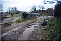
Evercreech Ford
This ford is found off Prestleigh Road at Evercreech. The location is at the point where the former railway crossed and the culvert crosses beneath the road.
Image: © John Walton
Taken: 18 Mar 2016
0.09 miles
2

Prestleigh Road, Evercreech
Looking North East towards Prestleigh and Shepton Mallet, the view includes an increasingly rare sight, a public phonebox.
Image: © J Tucker
Taken: 28 May 2007
0.19 miles
3

Climbing the Mendips on the S&D -1962
The Somerset and Dorset Railway climbed for some 7 miles from Evercreech Junction to Masbury summit mainly at 1 in 50. Holiday period trains particularly on a Saturday involved heavy loads – this train consisted of 11 coaches and a parcels van – and most such trains were hauled by two locomotives. A skilled eye can identify those at the head of this train being the same combination that Ben Brooksbank captured in this view https://www.geograph.org.uk/photo/2122053 . At this point the bulk of the climb still lies ahead.
Image: © Alan Murray-Rust
Taken: Unknown
0.21 miles
