IMAGES TAKEN NEAR TO
Kale Street, SHEPTON MALLET, BA4 6AB
Introduction
This page details the photographs taken nearby to Kale Street, BA4 6AB by members of the Geograph project.
The Geograph project started in 2005 with the aim of publishing, organising and preserving representative images for every square kilometre of Great Britain, Ireland and the Isle of Man.

There are currently over 7.5m images from over14,400 individuals and you can help contribute to the project by visiting https://www.geograph.org.uk
Image Map
Images are licensed for reuse under creativecommons.org/licenses/by-sa/2.0
Notes
- Clicking on the map will re-center to the selected point.
- The higher the marker number, the further away the image location is from the centre of the postcode.
Image Listing (44 Images Found)
Images are licensed for reuse under creativecommons.org/licenses/by-sa/2.0
Image
Details
Distance
1
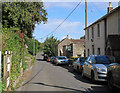
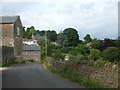
2011 : Kale Street, Batcombe
Heading east toward Upton Noble.
The green sign proclaims "Designers Makers" what they design and what they make have been unable to discover, even with the power of the web.
Image: © Maurice Pullin
Taken: 27 Aug 2011
0.02 miles
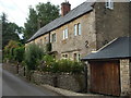
2
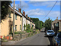
2011 : Cottages in Kale Street, Batcombe
Signs of roof repairs bottom left. Pretty successful top left.
Kale Street heads east out of the village to the A359 and Upton Noble.
Image: © Maurice Pullin
Taken: 27 Aug 2011
0.02 miles
3
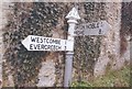
Old Direction Sign - Signpost by Kale Street, Batcombe
Pyramid finial - 2 arms; Somerset SCC pyramid by the UC road, in parish of Batcombe (Mendip District), Kale Street junction with Gold Hill and Back Lane.
Surveyed
Milestone Society National ID: SO_ST6939B
Image: © Milestone Society
Taken: Unknown
0.04 miles
4
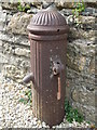
A village with mains
Batcombe has sheltered in the Alham valley and hence modern facilities were a little late arriving. Electricity didn't arrive until 1933; mains water came at last in 1952. This pillar would have been a central point in its day as water was drawn by the locals. See Image] for a wider view.
Image: © Neil Owen
Taken: 8 Jul 2019
0.04 miles
5
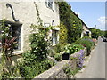
Cottages on Gold Hill
There used to be a Reading Room near here in the past. In front of the houses is a water pillar - see Image
Image: © Neil Owen
Taken: 8 Jul 2019
0.04 miles
6
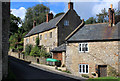
Row of cottages in Batcombe, Somerset
A sleepy village scene!
Image: © Jonathan Billinger
Taken: 5 Jun 2007
0.04 miles
7
2011 : Cottages in Batcombe
On my first visit to Batcome the impression I had was of a small but lively village, an impression borne out by its website.
"The village of Batcombe has a long history that goes back to Saxon times. It became rich in the 14th century due to the woollen trade and it was during this time that the very fine Parish Church of St Mary the Blessed Virgin was built to replace the earlier structure. It boasts a fine tower which affords splendid views of the beautiful valley in which Batcombe nestles.
Local Mendip limestone has historically been used to construct the local cottages and houses, many of which date from the 17th and 18th centuries."
The above was copied from: http://www.batcombe.org.uk/history.htm an informative website.
Image: © Maurice Pullin
Taken: 27 Aug 2011
0.05 miles
8
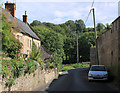
2011 : Gold Hill, Batcombe
Looking toward the River Alham.
Image: © Maurice Pullin
Taken: 27 Aug 2011
0.05 miles
9
Gold Hill, Batcombe
A general view across the east side of the village.
Image: © Neil Owen
Taken: 8 Jul 2019
0.07 miles
10
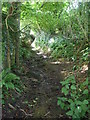
A wet walk
The footpath rising from Batcombe to Cockpit Lane starts right along a stream - a spring is just up the hill.
Image: © Neil Owen
Taken: 8 Jul 2019
0.07 miles