IMAGES TAKEN NEAR TO
Beech Avenue, SHEPTON MALLET, BA4 5XE
Introduction
This page details the photographs taken nearby to Beech Avenue, BA4 5XE by members of the Geograph project.
The Geograph project started in 2005 with the aim of publishing, organising and preserving representative images for every square kilometre of Great Britain, Ireland and the Isle of Man.

There are currently over 7.5m images from over14,400 individuals and you can help contribute to the project by visiting https://www.geograph.org.uk
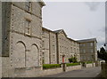
Image Map
Images are licensed for reuse under creativecommons.org/licenses/by-sa/2.0
Notes
- Clicking on the map will re-center to the selected point.
- The higher the marker number, the further away the image location is from the centre of the postcode.
Image Listing (30 Images Found)
Images are licensed for reuse under creativecommons.org/licenses/by-sa/2.0
Image
Details
Distance
1
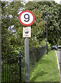
And not a mile an hour more
Perhaps this is a sign of impending metrification?
Image: © Neil Owen
Taken: 21 May 2014
0.18 miles
2
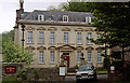
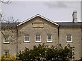
Bowlish House, Shepton Mallet
One of several big houses in Bowlish - this dates from 1732. Every window has a triangular or segmental pediment. The general proportions suggest early C18th and a provincial builder at work. Grade II* listed.
It is now a hotel and restaurant.
Image: © Stephen Richards
Taken: 13 May 2004
0.18 miles
3
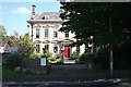
Shepton Mallet: Bowlish House
A Georgian clothier’s house built in 1732. It has since served as a restaurant
Image: © Martin Bodman
Taken: 21 Sep 2008
0.18 miles
4
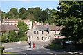
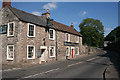
Shepton Mallet: Bowlish
Old Bowlish House is half hidden by the road junction. The Horseshoe Inn stands by the Shepton - Wells road, constructed in the 19th century. The old road runs behind the inn. On the right, in shadow, under the tree, is the entrance to Bowlish House, like Old Bowlish House, originally constructed for a wealthy cloth merchant, but more recently functioning as a restaurant
Image: © Martin Bodman
Taken: 21 Sep 2008
0.19 miles
5

Shepton Mallet: Sheppey at Darshill
The A371 Shepton-Wells road runs beside the river Sheppey and was opened to traffic in 1851. Photo taken near the site of Upper Darshill Mill, now occupied by a housing block
Image: © Martin Bodman
Taken: 8 Nov 2008
0.20 miles
6

Former Union Workhouse at West Shepton
Converted to residential use.
Image: © Roger Cornfoot
Taken: 31 Aug 2024
0.20 miles
7
Bowditch Close
The large and imposing former Union Workhouse is now much different in its welcome. What was once a dreadful place that the poor feared is now an exclusive property that only the rich can afford.
Founded in around 1848, the workhouse was designed by Charles Wainwright, based on the Square Plan. It housed nearly 200 inmates at its peak before the facility was converted in the 1930s into a mental health facility. It was renamed the Norah Fry Hospital after a trail-blazing Bristol nurse who devoted most of her life to this institution.
But the buildings were finally closed in the 1990s and lay disused until 2004, whereupon they were converted into town houses and apartments.
See Image] for the date stone.
Image: © Neil Owen
Taken: 21 May 2014
0.21 miles
8
The Union Workhouse
Shepton Mallet's grimmer history is now a modern and attractive residential property. See Image] for another view and some more information.
Image: © Neil Owen
Taken: 21 May 2014
0.21 miles
9
Shepton Mallet: The Horseshoe Inn
By the Shepton Mallet - Wells road, which was only constructed through the valley in the 19th century. Behind the inn stood one of Shepton’s silk mills which was demolished in 1974, according to Robin Bush [Somerset, The Complete Guide. Dovecote Press, 1994]
Image: © Martin Bodman
Taken: 21 Sep 2008
0.21 miles
10
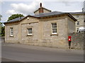
The Lodge
An unassuming if functional appearance of the Lodge, marking the entrance to the old Shepton Mallet Union Workhouse. A benchmark from the 1800s can be found on the corner angle - see Image
Image: © Neil Owen
Taken: 21 May 2014
0.21 miles