IMAGES TAKEN NEAR TO
Monmouth Road, SHEPTON MALLET, BA4 5SY
Introduction
This page details the photographs taken nearby to Monmouth Road, BA4 5SY by members of the Geograph project.
The Geograph project started in 2005 with the aim of publishing, organising and preserving representative images for every square kilometre of Great Britain, Ireland and the Isle of Man.

There are currently over 7.5m images from over14,400 individuals and you can help contribute to the project by visiting https://www.geograph.org.uk
Image Map
Images are licensed for reuse under creativecommons.org/licenses/by-sa/2.0
Notes
- Clicking on the map will re-center to the selected point.
- The higher the marker number, the further away the image location is from the centre of the postcode.
Image Listing (26 Images Found)
Images are licensed for reuse under creativecommons.org/licenses/by-sa/2.0
Image
Details
Distance
1
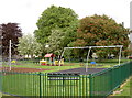
Queens Road playground
A smart and modern play area.
Image: © Neil Owen
Taken: 21 May 2014
0.07 miles
2
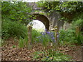
Bluebells and the bridge
Some seasonal flowers in front of the old railway line; the tunnel links Kent with Queens Road.
Image: © Neil Owen
Taken: 21 May 2014
0.10 miles
3
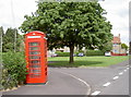
Box on the green
A telephone kiosk on the corner of the small green space of Christopher Way.
Image: © Neil Owen
Taken: 21 May 2014
0.10 miles
4

West Shepton
This is the B3136 which runs south west out of the town to Pilton. This is looking north east at the old town boundary.
Image: © Nigel Mykura
Taken: 14 Apr 2012
0.16 miles
5
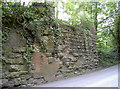
Bridge made of many parts
This former railway bridge on the way from Lambert's Hill has a mixed appearance - not derived from the dismantling. There is a benchmark on the brickwork - see Image
Image: © Neil Owen
Taken: 21 May 2014
0.19 miles
6

On the bricks
This benchmark on the dismantled railway bridge happens to have been put on the brickwork. See http://www.bench-marks.org.uk/bm57530 for the entry in the Benchmark Database and Image] for a wider view.
Image: © Neil Owen
Taken: 21 May 2014
0.19 miles
7
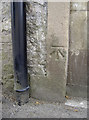
Benchmark on East Somerset House
An old mark, as listed in the Benchmark Database: http://www.bench-marks.org.uk/bm57533 , on what is now a funeral directors. See Image] for a wider view.
Image: © Neil Owen
Taken: 21 May 2014
0.20 miles
8
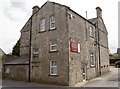
Funeral Directors on West Shepton
Formerly known as East Somerset House, it has a benchmark from the 1800s on the blocked off doorway - see Image
Image: © Neil Owen
Taken: 21 May 2014
0.20 miles

10

Railway bridge abutments, south of Shepton Mallet
Image: © Roger Cornfoot
Taken: 31 Aug 2024
0.20 miles