IMAGES TAKEN NEAR TO
Cornhill, SHEPTON MALLET, BA4 5LT
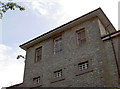
Introduction
This page details the photographs taken nearby to Cornhill, BA4 5LT by members of the Geograph project.
The Geograph project started in 2005 with the aim of publishing, organising and preserving representative images for every square kilometre of Great Britain, Ireland and the Isle of Man.

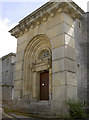
There are currently over 7.5m images from over14,400 individuals and you can help contribute to the project by visiting https://www.geograph.org.uk
Image Map
Images are licensed for reuse under creativecommons.org/licenses/by-sa/2.0
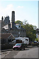
Notes
- Clicking on the map will re-center to the selected point.
- The higher the marker number, the further away the image location is from the centre of the postcode.
Image Listing (216 Images Found)
Images are licensed for reuse under creativecommons.org/licenses/by-sa/2.0
Image
Details
Distance
1
Shepton Mallet: towards Town Mill, Leg Square
This mill was rebuilt at least once in the 19th century, following fires. It served briefly as a silk mill, before reverting to its original function as a grain mill. It was powered by a water wheel as well as steam: a high level leat, mostly culverted, ran in from ponds at Kilver Street. Beyond stands the tower of the church dedicated to St Peter and St Paul
Image: © Martin Bodman
Taken: 21 Sep 2008
0.01 miles
2
Looking within at those without
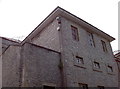
H.M.P. Shepton Mallet, also known as Cornhill, once provided a treadmill that held forty inmates. The power created by them was used to run a flour mill until 1890. See Image] for another view.
Image: © Neil Owen
Taken: 30 Jul 2012
0.02 miles
3
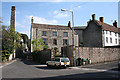
Shepton Mallet: Leg Square
With the chimney of Town Mill on the left. The building seen through the gap to the right of the lamp post is a wing of Shepton Mallet gaol, built in 1817-1822
Image: © Martin Bodman
Taken: 21 Sep 2008
0.02 miles
4
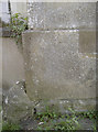
Benchmark on the nick
Shepton Mallet has long had a place of detention, and this benchmark has been in place since the nineteenth century. See http://www.bench-marks.org.uk/bm45334 in the Benchmark Database and Image] for a wider view.
Image: © Neil Owen
Taken: 30 Jul 2012
0.02 miles
5
North entrance to Shepton Mallet prison
It's had a long and notable history, from its founding after the King James I act of 1609 to the present day. This is the north entrance, or exit - depending on your point of view. See Image] for the walls and Image] for a benchmark on the left of the doorway.
Image: © Neil Owen
Taken: 30 Jul 2012
0.02 miles
6
No cold callers
The unapologetic exterior of Britain's oldest working prison, now holding category 'C' lifers. Apart from a brief closure in the 1930s this house of detention has held many inmates in its time, seen many escape attempts and held executions (several of which were military). See Image] for another look.
Image: © Neil Owen
Taken: 30 Jul 2012
0.02 miles
7
The Dusthole, Shepton Mallet
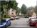
Located on the north side of Garston Street, adjacent to Leg Square.
Also known as The Kings Arms, this a modernised former coaching inn dating back several centuries. The accommodation is 10 en-suite bedrooms.
Image: © Jaggery
Taken: 7 Jul 2010
0.03 miles
8
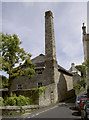
A tall chimney
Located at the junction of Leg Square and Cornhill, not far from the prison, this was a former mill served by a watercourse.
Image: © Neil Owen
Taken: 30 Jul 2012
0.03 miles
9
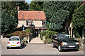
Shepton Mallet: The Kings Arms
By Leg Square, near Quarr
Image: © Martin Bodman
Taken: 21 Sep 2008
0.03 miles
10
The Dusthole
'An Inn for all seasons' proclaims the board. Of course the inn is actually called the King's Arms, but the locals prefer to refer to this watering hole as The Dusthole.
Image: © Neil Owen
Taken: 30 Jul 2012
0.03 miles