IMAGES TAKEN NEAR TO
Princes Road, SHEPTON MALLET, BA4 5HL
Introduction
This page details the photographs taken nearby to Princes Road, BA4 5HL by members of the Geograph project.
The Geograph project started in 2005 with the aim of publishing, organising and preserving representative images for every square kilometre of Great Britain, Ireland and the Isle of Man.

There are currently over 7.5m images from over14,400 individuals and you can help contribute to the project by visiting https://www.geograph.org.uk
Image Map
Images are licensed for reuse under creativecommons.org/licenses/by-sa/2.0
Notes
- Clicking on the map will re-center to the selected point.
- The higher the marker number, the further away the image location is from the centre of the postcode.
Image Listing (199 Images Found)
Images are licensed for reuse under creativecommons.org/licenses/by-sa/2.0
Image
Details
Distance
2
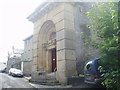
Shepton Mallet Gaol
The old rear door of the oldest working Gaol in Britain dating from 1610. It was closed between 1930 and 1939 but reopened as an English/American Military 'establishment' between 1939 and 1966. It is nowadays a prison once more. It was in this prison that the notorious Kray twins met Charlie Richardson. They were serving out their 'national service' after absconding.
Image: © Nigel Freeman
Taken: 2 Aug 2005
0.08 miles
3

Shepton Mallet: footbridge
The bridge carries a footpath – Edengrove Lane – over the river Sheppey and Lower Lane
Image: © Martin Bodman
Taken: 21 Sep 2008
0.10 miles
4

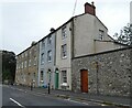
Waterloo Road
The building on the right here is the Liberal Club and Mechanics Hall according to the inscription above the door.
Image: © Des Blenkinsopp
Taken: 27 Aug 2014
0.11 miles
5

Footpath to Barren Down
The path crosses over the River Sheppy here.
Image: © Neil Owen
Taken: 21 May 2014
0.11 miles
6

Keeping out of the water
The stream running along Lower Lane is well protected as it disappears under the road.
Image: © Neil Owen
Taken: 21 May 2014
0.11 miles
7

Footbridge over the Sheppey
Part of the Lower Lane area of Shepton Mallet and the river that runs down here makes for an interesting little bridge over it.
Image: © Neil Owen
Taken: 21 May 2014
0.11 miles
8
Shepton Mallet: Waterloo Bridge
Waterloo Road crosses Lower Lane and the river Sheppey: the bridge dates from 1832
Image: © Martin Bodman
Taken: 21 Sep 2008
0.11 miles
9
Shepton Mallet: Longbridge House
In Cowl Street. A plaque on the wall proclaims that the Duke of Monmouth stayed here before his defeat at the Battle of Sedgemoor in July 1685. But according to Robin Bush, in Somerset, The Complete Guide, tradition has it that the duke lodged at Monmouth House, demolished in 1964. Longbridge House was occupied by a clothier in the late 18th century
Image: © Martin Bodman
Taken: 21 Sep 2008
0.11 miles
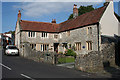
10
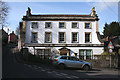
Shepton Mallet: No 1, Leg Square
This house, once known as ‘Eden Grove’ was built circa 1750 and is now listed Grade II. A Georgian house, built for a clothier or woollen merchant
Image: © Martin Bodman
Taken: 2 Mar 2009
0.12 miles