IMAGES TAKEN NEAR TO
Gold Hill, SHEPTON MALLET, BA4 5EJ
Introduction
This page details the photographs taken nearby to Gold Hill, BA4 5EJ by members of the Geograph project.
The Geograph project started in 2005 with the aim of publishing, organising and preserving representative images for every square kilometre of Great Britain, Ireland and the Isle of Man.

There are currently over 7.5m images from over14,400 individuals and you can help contribute to the project by visiting https://www.geograph.org.uk
Image Map
Images are licensed for reuse under creativecommons.org/licenses/by-sa/2.0
Notes
- Clicking on the map will re-center to the selected point.
- The higher the marker number, the further away the image location is from the centre of the postcode.
Image Listing (55 Images Found)
Images are licensed for reuse under creativecommons.org/licenses/by-sa/2.0
Image
Details
Distance
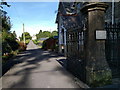
2
Bridge on Cowl Street
There is an Ordnance Survey bench mark on the wall of the bridge.
Image: © Maigheach-gheal
Taken: 31 Aug 2011
0.04 miles
3
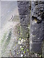
Bench Mark, Cowl Street
The bench mark is on the northwest side of the bridge. For a view of the bridge Image and for further information on the bench mark and others in the area http://www.bench-marks.org.uk/bm39639
Image: © Maigheach-gheal
Taken: 31 Aug 2011
0.04 miles
4
Windsor Hill 1 Mile
The paint is somewhat faded but at least the routered legend is readable. Footpath sign at the junction of Gold Hill and Cowl Street.
Image: © Neil Owen
Taken: 21 May 2014
0.05 miles
5

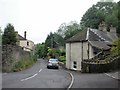
Cowl Street, Shepton Mallet
Looking along Cowl Street.
Image: © Maigheach-gheal
Taken: 31 Aug 2011
0.05 miles
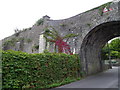
6
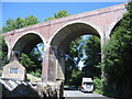
Viaduct at Shepton Mallet
A view looking to the northeast along the B3136 Bath Road, towards the viaduct which once carried the Somerset and Dorset Joint Railway. Note the seam within the arches, resulting from widening operations in 1892.
Image: © Phil Williams
Taken: 18 Jul 2007
0.07 miles
7
Cowl Street, Shepton Mallet
Near the Bath Road viaduct http://www.geograph.org.uk/photo/1951762, Cowl Street heads away from the B3136 at the point where the B road's local name changes from Bath Road to Waterloo Road.
Image: © Jaggery
Taken: 7 Jul 2010
0.07 miles
8
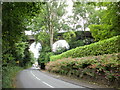
Shepton Mallet : Bath Road viaduct viewed from the north
Formerly part of the Somerset and Dorset Joint Railway, and later British Railways, the viaduct was rebuilt during the first half of 1946. The viaduct became redundant in the 1960s when all passenger services to Shepton Mallet ceased. Nowadays, the nearest Network Rail station is Castle Cary, about eight miles south of Shepton Mallet.
http://www.geograph.org.uk/photo/1248339 to the view from the other side, and links to a brief history and possible future plans.
Image: © Jaggery
Taken: 7 Jul 2010
0.07 miles
9
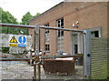
The lights have gone out
The former electricity substation in Cowl Street has been switched off for some time now. In living memory this area had the electricity and gas holder to power Shepton Mallet but both are now history.
Image: © Neil Owen
Taken: 21 May 2014
0.07 miles
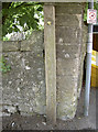
10
Ordnance Survey Benchmark, Cowl Street
Image: © Barbara Voules
Taken: 29 Apr 2016
0.10 miles