IMAGES TAKEN NEAR TO
Park Road, SHEPTON MALLET, BA4 5BS
Introduction
This page details the photographs taken nearby to Park Road, BA4 5BS by members of the Geograph project.
The Geograph project started in 2005 with the aim of publishing, organising and preserving representative images for every square kilometre of Great Britain, Ireland and the Isle of Man.

There are currently over 7.5m images from over14,400 individuals and you can help contribute to the project by visiting https://www.geograph.org.uk
Image Map
Images are licensed for reuse under creativecommons.org/licenses/by-sa/2.0
Notes
- Clicking on the map will re-center to the selected point.
- The higher the marker number, the further away the image location is from the centre of the postcode.
Image Listing (222 Images Found)
Images are licensed for reuse under creativecommons.org/licenses/by-sa/2.0
Image
Details
Distance
1
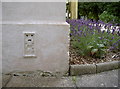
Flush Bracket
Number 10724, somewhat coated over the years with masonry paint, but still recognisable. See Image] for a wider view of its location on the Mendip Council office block, and see http://www.bench-marks.org.uk/bm18787 for the entry in the Benchmark Database.
Image: © Neil Owen
Taken: 30 Jul 2012
0.02 miles
2

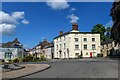
Council Offices
The estate in Shepton Mallet houses a number of different styles of architecture within it, and the council has a large presence. This one appears to be of older design, with a later addition to the left. Incidentally, a Flush Bracket is located on the white wall facing the addition - see Image] for a closer view.
Image: © Neil Owen
Taken: 30 Jul 2012
0.02 miles
3

Shepton Mallet: Mendip District Council offices
By the path to reception
Image: © Martin Bodman
Taken: 21 Sep 2008
0.03 miles
4

Putting the roof on
Construction on the site of the council offices.
Image: © Neil Owen
Taken: 21 May 2014
0.05 miles
5
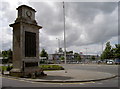
War memorial
Shepton Mallet's striking war memorial stands at the southern end of what was the full extent of the High Street. Now it's facing a roundabout, has a Tesco's to its left and traffic rushes past it on both sides.
The memorial was erected in 1920 to honour the fallen of the Great War, with funding coming from the public, and the official unveiling held on 11th November. Constructed from Portland Stone it was designed by Bristol architect CFW Denning and crafted by Bath mason Lewis Smallcorn.
Image: © Neil Owen
Taken: 30 Jul 2012
0.05 miles
6

Roundabout, Shepton Mallett
Seen from Cannard's Grave Road, the High Street is straight ahead and Park Road to the right.
Image: © John Baker
Taken: 4 Apr 2016
0.06 miles
7

Busy roundabout
The junction of Cannard's Grave Road, Station Road, Townsend, Park Road and the High Street, with the stores and fuel station as a background.
Image: © Neil Owen
Taken: 30 Jul 2012
0.06 miles
8
Shepton Mallet : High Street
Off Cannard's Grave Road.
Image: © Lewis Clarke
Taken: 19 Jun 2023
0.07 miles
9
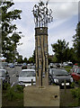
Shepton's Mallet
A curious sculpture near the Townsend/Station Road roundabout bears a number of images and an inscription which initially reads thus:
'Shepton's Mallet
This artwork by Peter Osborne is a 3.8 metre tall metal and mortar obelisk in the shape of a stylised mallet.
The work's chosen form draws on the town's name derived from one William Malet, a companion of William the Conqueror, who, for the services he rendered, was gifted with various lands including those around Shepton Mallet.
It was during those times that the use of surnames was fully implemented within these isles of Britain by the Norman invaders in order to categorise all of its inhabitants.
The Malet name is of French origin and its meaning comes from two sources: from the ancient Norse, it found its way south into the French family surname system, meaning 'Maul' or 'Mallet' as in the God of Thunder, the metalsmith 'Thor; it is also said at the time in France the name meant 'maligned one' or 'outcast'.
See Image] for another view of this work.
Image: © Neil Owen
Taken: 30 Jul 2012
0.07 miles
10
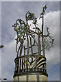
Hiding Dove
According to the information, there is a dove amongst the metal foliage. See Image] for a better look.
Image: © Neil Owen
Taken: 30 Jul 2012
0.07 miles