IMAGES TAKEN NEAR TO
Kiln Close, SHEPTON MALLET, BA4 4UB
Introduction
This page details the photographs taken nearby to Kiln Close, BA4 4UB by members of the Geograph project.
The Geograph project started in 2005 with the aim of publishing, organising and preserving representative images for every square kilometre of Great Britain, Ireland and the Isle of Man.

There are currently over 7.5m images from over14,400 individuals and you can help contribute to the project by visiting https://www.geograph.org.uk
Image Map
Images are licensed for reuse under creativecommons.org/licenses/by-sa/2.0
Notes
- Clicking on the map will re-center to the selected point.
- The higher the marker number, the further away the image location is from the centre of the postcode.
Image Listing (39 Images Found)
Images are licensed for reuse under creativecommons.org/licenses/by-sa/2.0
Image
Details
Distance
1

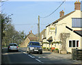
2009 : The St. Wanstrow
That is what it is called on the map, "The St." The A359 forms two arms of the crossroads and Church St. behind. The Pub stands on the corner to the right.
Note the green wheely bins and the post box.
Image: © Maurice Pullin
Taken: 20 Mar 2009
0.03 miles
2
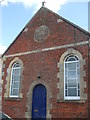
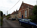
The Primitive Methodist chapel in Wanstrow
Dissenters in the village used to have to use homes or inadequate meeting rooms, along with having to be granted a licence to do so. A Wesleyan church was built in 1835 (now demolished but recalled in the modern Wesley Close) and this Primitive chapel came along in 1877. The founding was on a site granted by a Mr W. Walwin and the designers and builders were Ashman and Son, of Leigh on Mendip. The cost was £235.
Image: © Neil Owen
Taken: 21 Jun 2019
0.04 miles
3
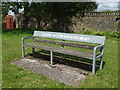
A sponsored bench in Wesley Close
A sturdy metal bench with an unusual message. A plaque describes it as being donated by Wanstrow Parish Council to commemorate V.E. Day in 1995.
Image: © Neil Owen
Taken: 21 Jun 2019
0.04 miles
5
2009 : The Pub, Station Road, Wanstrow
The name is original at least, I haven't seen a public house called that before.
For the time being you can find it on http://maps.google.co.uk/maps?hl=en&safe=off&cr=countryUK%7CcountryGB&um=1&ie=UTF-8&q=The+Pub+Wanstrow&fb=1&split=1&gl=uk&view=text&latlng=17199587160163860994
Image: © Maurice Pullin
Taken: 20 Mar 2009
0.06 miles
6

A rural reminder
An old piece of agricultural equipment lies (presumably unused) in a small patch of grass in Wanstrow. A nice little bit of rustic decoration.
Image: © Neil Owen
Taken: 21 Jun 2019
0.07 miles
7
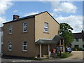
Right on the crossroads
The main road crosses the middle of Wanstrow and naturally is a focal point. This building used to be the first pub, known originally as The Otter's Head; it changed to the Queen's Head, the Wanstrow Inn, before being split and sold to become the Post Office and a private residence. The role as the post office ended fairly recently as the service moved to the village hall.
A benchmark can be seen on the corner - Image
Image: © Neil Owen
Taken: 21 Jun 2019
0.07 miles
8
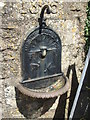
An old tap beside the pub tap
One of four such public water taps provided in 1885. The tap is not extant, but the bowl survives.
Image: © Neil Owen
Taken: 21 Jun 2019
0.07 miles
9
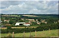
2007 : From Hunters Lodge Farm
Overlooking Sturton Farm with Wanstrow Village behind.
Cranmore is on the other side of the hills.
Image: © Maurice Pullin
Taken: 28 Jul 2007
0.07 miles
10
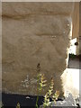
Benchmark on the old post office
Wanstrow's former Post Office (and prior to that, a former pub) bears a cutmark of nineteenth century vintage. See Image] for a wider view and https://www.bench-marks.org.uk/bm108880 for the log in the Benchmark Database.
Image: © Neil Owen
Taken: 21 Jun 2019
0.07 miles