IMAGES TAKEN NEAR TO
Amulet Way, SHEPTON MALLET, BA4 4TJ
Introduction
This page details the photographs taken nearby to Amulet Way, BA4 4TJ by members of the Geograph project.
The Geograph project started in 2005 with the aim of publishing, organising and preserving representative images for every square kilometre of Great Britain, Ireland and the Isle of Man.

There are currently over 7.5m images from over14,400 individuals and you can help contribute to the project by visiting https://www.geograph.org.uk
Image Map
Images are licensed for reuse under creativecommons.org/licenses/by-sa/2.0
Notes
- Clicking on the map will re-center to the selected point.
- The higher the marker number, the further away the image location is from the centre of the postcode.
Image Listing (23 Images Found)
Images are licensed for reuse under creativecommons.org/licenses/by-sa/2.0
Image
Details
Distance

2

Charlton Trading Estate
One of the ponds on the trading estate.
Image: © Paul Berry
Taken: 22 Jul 2016
0.10 miles
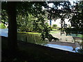
3

The upper pond
The River Sheppey runs westwards to Shepton Mallet but before it gets to the town it is gathered into a couple of ponds. The older was part of a malthouse and brewery and is nineteenth century, whereas this one (the upper) is at least a century younger.
Image: © Neil Owen
Taken: 26 Aug 2020
0.10 miles
4
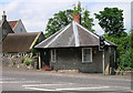
Old Toll House by Charlton Road, Shepton Mallet
Toll House in the parish of Shepton Mallet, Turnpike Cottage, 67, Charlton Road.
Grade II listed.
List Entry Number: 1345201 https://historicengland.org.uk/listing/the-list/list-entry/1345201
Surveyed
Milestone Society National ID: SO.SHN02
Image: © Alan Rosevear
Taken: Unknown
0.11 miles
5
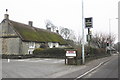
The Thatched Cottage, Charlton Road, Shepton Mallet
Image: © Roger Cornfoot
Taken: 27 Jan 2010
0.12 miles
6

Garden Centre Car Park
Dobbies garden centre car park Shepton Mallett
Image: © Shaun Ferguson
Taken: 29 Jul 2016
0.13 miles
7
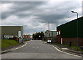
2011 : Fosse Lane Trading Estate, Shepton Mallet
South of the A361 Charlton Road.
Image: © Maurice Pullin
Taken: 11 Jun 2011
0.14 miles
8
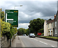
2011 : A361 Charlton Road, Shepton Mallet
Heading east out of Shepton Mallet, nearly at Charlton.
Image: © Maurice Pullin
Taken: 11 Jun 2011
0.15 miles
9

Shepton Mallet: brewery millpond
The pond water provided the power for a 19th century brewery, built on the site of an old woollen mill. This was one of many water-powered sites which once utilised the water of the river Sheppey – its source is at St Aldhelm’s Well in the neighbouring parish of Doulting
Image: © Martin Bodman
Taken: 8 Aug 2008
0.16 miles
10
A mill pond for the malthouse
Now a feature of a modern business park, the mill pond used to be part of a malthouse.
Image: © Neil Owen
Taken: 26 Aug 2020
0.16 miles