IMAGES TAKEN NEAR TO
Station Road, SHEPTON MALLET, BA4 4SY
Introduction
This page details the photographs taken nearby to Station Road, BA4 4SY by members of the Geograph project.
The Geograph project started in 2005 with the aim of publishing, organising and preserving representative images for every square kilometre of Great Britain, Ireland and the Isle of Man.

There are currently over 7.5m images from over14,400 individuals and you can help contribute to the project by visiting https://www.geograph.org.uk
Image Map
Images are licensed for reuse under creativecommons.org/licenses/by-sa/2.0
Notes
- Clicking on the map will re-center to the selected point.
- The higher the marker number, the further away the image location is from the centre of the postcode.
Image Listing (36 Images Found)
Images are licensed for reuse under creativecommons.org/licenses/by-sa/2.0
Image
Details
Distance
1
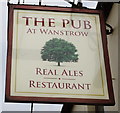
2009 : The Pub, Station Road, Wanstrow
The name is original at least, I haven't seen a public house called that before.
For the time being you can find it on http://maps.google.co.uk/maps?hl=en&safe=off&cr=countryUK%7CcountryGB&um=1&ie=UTF-8&q=The+Pub+Wanstrow&fb=1&split=1&gl=uk&view=text&latlng=17199587160163860994
Image: © Maurice Pullin
Taken: 20 Mar 2009
0.09 miles
2
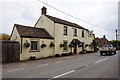
The Pub at Wanstrow
http://www.geograph.org.uk/photo/5085751 http://www.geograph.org.uk/photo/5085755
Image: © Ian S
Taken: 27 May 2016
0.10 miles
3
The Pub at Wanstrow
http://www.geograph.org.uk/photo/5085748 http://www.geograph.org.uk/photo/5085755
Image: © Ian S
Taken: 27 May 2016
0.10 miles
4
The Pub at Wanstrow
http://www.geograph.org.uk/photo/5085748 http://www.geograph.org.uk/photo/5085751
Image: © Ian S
Taken: 27 May 2016
0.10 miles
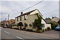
5
The King William IV
Wanstrow's remaining inn is now known as the King William IV. In a recent incarnation it was called The Pub. In previous times it was the King's Head, The Railway Hotel (when the trains arrived) before reclaiming its modern title.
Image: © Neil Owen
Taken: 21 Jun 2019
0.10 miles
7
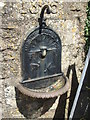
An old tap beside the pub tap
One of four such public water taps provided in 1885. The tap is not extant, but the bowl survives.
Image: © Neil Owen
Taken: 21 Jun 2019
0.11 miles
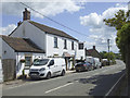
8
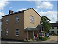
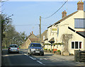
Right on the crossroads
The main road crosses the middle of Wanstrow and naturally is a focal point. This building used to be the first pub, known originally as The Otter's Head; it changed to the Queen's Head, the Wanstrow Inn, before being split and sold to become the Post Office and a private residence. The role as the post office ended fairly recently as the service moved to the village hall.
A benchmark can be seen on the corner - Image
Image: © Neil Owen
Taken: 21 Jun 2019
0.11 miles
9
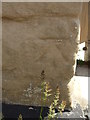
Benchmark on the old post office
Wanstrow's former Post Office (and prior to that, a former pub) bears a cutmark of nineteenth century vintage. See Image] for a wider view and https://www.bench-marks.org.uk/bm108880 for the log in the Benchmark Database.
Image: © Neil Owen
Taken: 21 Jun 2019
0.12 miles