IMAGES TAKEN NEAR TO
East Cranmore, SHEPTON MALLET, BA4 4SD
Introduction
This page details the photographs taken nearby to BA4 4SD by members of the Geograph project.
The Geograph project started in 2005 with the aim of publishing, organising and preserving representative images for every square kilometre of Great Britain, Ireland and the Isle of Man.

There are currently over 7.5m images from over14,400 individuals and you can help contribute to the project by visiting https://www.geograph.org.uk
Image Map
Images are licensed for reuse under creativecommons.org/licenses/by-sa/2.0
Notes
- Clicking on the map will re-center to the selected point.
- The higher the marker number, the further away the image location is from the centre of the postcode.
Image Listing (13 Images Found)
Images are licensed for reuse under creativecommons.org/licenses/by-sa/2.0
Image
Details
Distance
1
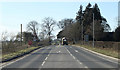
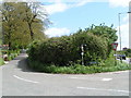
2011 : A361 heading west for Doulting
Then Shepton Mallet.
A load of ready mixed concrete approaches.
Image: © Maurice Pullin
Taken: 8 Feb 2011
0.03 miles
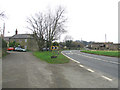
2
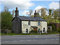
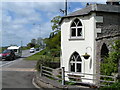
Turnpike Cottage
A former toll house on what is now the A361.
Image: © Robin Webster
Taken: 2 Apr 2017
0.13 miles
3
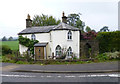
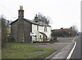
Old Toll House, East Cranmore
Turnpike Cottage, at the junction of Slait Hill, Turnpike Lane and the A361, BA4 4LL.
Grade II listed.
List Entry Number: 1058525 https://historicengland.org.uk/listing/the-list/list-entry/1058525
Surveyed
Milestone Society National ID: SO.CRA
Image: © Alan Rosevear
Taken: 3 Oct 2013
0.14 miles
4
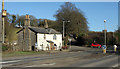
2011 : Old toll house on the A361
With Slait Hill heading north to Downhead.
The toll house is still for sale.
A small car waits to emerge onto the A361.
Image: © Maurice Pullin
Taken: 8 Feb 2011
0.15 miles
5
Old toll house at the bottom of Slait Hill
Image: © Rob Purvis
Taken: 8 May 2009
0.15 miles
6
Former toll house, on the A361, near East Cranmore
Image: © Roger Cornfoot
Taken: 27 Jan 2010
0.15 miles
7
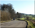
2011 : Turnpike Lane leading to Cranmore
A few yards off the A361.
Image: © Maurice Pullin
Taken: 8 Feb 2011
0.17 miles
8
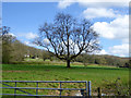
Tree in field east of Turnpike Lane
And south of the old turnpike, now the A361, beyond the far hedge.
Image: © Robin Webster
Taken: 2 Apr 2017
0.18 miles
10
Dean
Dean is a very small hamlett with a main road (A361) running through the middle of it. Taken on a very dull day.
Image: © Barbara Voules
Taken: 18 Feb 2007
0.20 miles