IMAGES TAKEN NEAR TO
Fosse Lane, SHEPTON MALLET, BA4 4PS
Introduction
This page details the photographs taken nearby to Fosse Lane, BA4 4PS by members of the Geograph project.
The Geograph project started in 2005 with the aim of publishing, organising and preserving representative images for every square kilometre of Great Britain, Ireland and the Isle of Man.

There are currently over 7.5m images from over14,400 individuals and you can help contribute to the project by visiting https://www.geograph.org.uk
Image Map
Images are licensed for reuse under creativecommons.org/licenses/by-sa/2.0
Notes
- Clicking on the map will re-center to the selected point.
- The higher the marker number, the further away the image location is from the centre of the postcode.
Image Listing (17 Images Found)
Images are licensed for reuse under creativecommons.org/licenses/by-sa/2.0
Image
Details
Distance
1

Garden Centre Car Park
Dobbies garden centre car park Shepton Mallett
Image: © Shaun Ferguson
Taken: 29 Jul 2016
0.09 miles

3
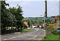
2011 : A37 Whitstone Road, Shepton Mallet
Facing north.
The A37 clips the eastern fringes of Shepton Mallet without causing too much trouble, a bypass further out would be very difficult.
Image: © Maurice Pullin
Taken: 4 Jul 2011
0.16 miles
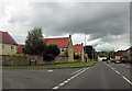
7
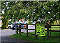
2011 : Ice Road Truckers coming to Shepton Mallet
Be needing a snow machine then.
Notice at the end of Whitstone Rise giving promise of delights to come.
Image: © Maurice Pullin
Taken: 4 Jul 2011
0.19 miles
8

Where Frog Lane gets watery
The lane peters out into a farm track at its end but also has a small stream for guidance.
Image: © Neil Owen
Taken: 26 Aug 2020
0.20 miles
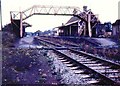
9
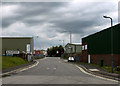
2011 : Fosse Lane Trading Estate, Shepton Mallet
South of the A361 Charlton Road.
Image: © Maurice Pullin
Taken: 11 Jun 2011
0.21 miles
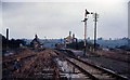
10
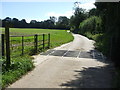
Frog Lane ends
The road becomes a concrete farm track from the cattle grid onwards. The hedgeline on the horizon was once a railway track.
Image: © Neil Owen
Taken: 26 Aug 2020
0.22 miles