IMAGES TAKEN NEAR TO
Pylle Road, SHEPTON MALLET, BA4 4HP
Introduction
This page details the photographs taken nearby to Pylle Road, BA4 4HP by members of the Geograph project.
The Geograph project started in 2005 with the aim of publishing, organising and preserving representative images for every square kilometre of Great Britain, Ireland and the Isle of Man.

There are currently over 7.5m images from over14,400 individuals and you can help contribute to the project by visiting https://www.geograph.org.uk
Image Map
Images are licensed for reuse under creativecommons.org/licenses/by-sa/2.0
Notes
- Clicking on the map will re-center to the selected point.
- The higher the marker number, the further away the image location is from the centre of the postcode.
Image Listing (12 Images Found)
Images are licensed for reuse under creativecommons.org/licenses/by-sa/2.0
Image
Details
Distance
4
Glastonbury Festival - looking west on track from the east carparks
Image: © Andy F
Taken: 26 Jun 2009
0.12 miles
5
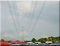
Glastonbury Festival - powerlines crossing over carpark E1
Image: © Andy F
Taken: 26 Jun 2009
0.12 miles
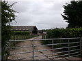
6
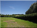
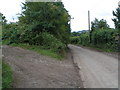
Field and hedge, Windinglake Farm
A view from Pylle Road, with the pylon line seen in Image crossing overhead.
Image: © Derek Harper
Taken: 22 Jul 2012
0.13 miles
7
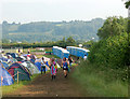
Glastonbury Festival - campsite and loos looking southwest
Image: © Andy F
Taken: 26 Jun 2009
0.16 miles
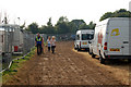
8
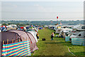
Glastonbury Festival - campsite under power lines
Image: © Andy F
Taken: 26 Jun 2009
0.17 miles
10
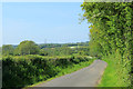
2012 : Pylle Road, heading north west to Pilton
About three quarters of a mile from Pylle, a mile and a half to Pilton through some pleasant Mendip country.
Image: © Maurice Pullin
Taken: 22 May 2012
0.22 miles